Destacada

Descubre nuestras villas

En este blog puedes encontrar información turística sobre las localidades de nuestra Mancomunidad

El que viaja mucho y lee mucho, ve mucho y sabe mucho.

— Cervantes

Mil tesoros te esperan en Alange, Aljucén, Don Álvaro, El Carrascalejo, Mirandilla, Trujillanos, San Pedro de Mérida, Oliva de Mérida, Valverde de Mérida, La Zarza y Villagonzalo … ¡ven a decubrirlos!

Villagonzalo

Iglesia de Villagonzalo

Próximo a la orilla izquierda del río Guadiana, sobre una extensa llanura rodeada de sierras, se asienta la localidad de Villagonzalo. Pertenece a la comarca de Tierra de Mérida-Vegas Bajas y al Partido Judicial de Mérida, situándose a 22 km de ésta.

Su fundación como aldea dependiente de la Encomienda de Alange, se atribuye en el siglo XIV al Maestre santiaguista Gonzalo Mexía, de quien deriva su apelativo.

En 1588 se independizó de este dominio mediante el pago de 7.000 ducados a Felipe II, tomando su Privilegio de Villazgo y quedando exenta de dicha Encomienda.

Sus habitantes adquieren el gentilicio de “villagonzalenses” pero son comúnmente más conocidos como “galapagueros” debido a “Las Galapagueras”; tierras de uso exclusivo para los ganaderos de la localidad.

Es un pueblo agrario en el que abunda la zona de regadío y también el olivo. Sus calles son anchas, destacando su arquitectura vernácula con algunas casas solariegas.

MONUMENTOS

IGLESIA PARROQUIAL NUESTRA SEÑORA DE LA PURÍSIMA CONCEPCIÓN

Entre los monumentos locales, el más destacado es la iglesia parroquial de Ntra. Sra. De la Purísima Concepción, obra del siglo XVI, realizado por Domingo Dorego, consta de una nave única dividida en dos tramos, con bóvedas de cañón y cabecera poligonal. Modificada sustancialmente en el siglo XVIII; y reconstruida casi por completo tras la Guerra Civil. En el interior, resulta de interés la puerta de la sacristía, de sencillo diseño clásico con frontón coronado por el escudo santiaguista. También en la Iglesia podemos encontrar la imagen del Cristo Nazareno, patrón de la localidad y obra temprana del escultor extremeño Juan de Ávalos. La importancia de esta obra es que pertenece a la primera etapa del escultor. La imagen del Cristo no es la original, la antigua imagen fue quemada en la plaza en la Guerra Civil.  

Señalar además el retablo mayor, obra moderna, de pequeñas proporciones y digna factura, realizada según los modelos barrocos.

En muros exteriores se observan la construcción de 10 contrafuertes de sección cuadrangular, efectuados en sillares de granito. Todo el exterior está pintado de un color ocre muy característico.

PLAZA DE ESPAÑA-COLUMNA TESTUDINIS

En el centro de la plaza de España, ubicada frente al Ayuntamiento, se encuentra la columna Testudinis, más conocida como el monumento al Galápago, creada por el pintor y escultor, descendiente de la localidad, Luis Ledo González en el año 1998. Esta obra fue inaugurada el 2 de agosto del año 2000.

Consta de un monolito de piedra que sirve de basamento, donde puede leerse: “Por cuanto concedo a Villagonzalo de la Orden de Santiago, privilegios de arbitrios en El Pardo. Anno MDCXXXIII, Philippo IV”.

Sobre esta base hay una columna de acero inoxidable con pivotes salientes a lo largo de toda ella y, en su cima, acabada en rampa, descansa la escultura de un galápago realizado en bronce, símbolo del apelativo de los vecinos.

ARQUITECTURA POPULAR

La arquitectura vernácula típica de las casas de la localidad se trata de casas de planta baja y doblado, -entre ellas algunas Casas Solariegas- anteriores al siglo XIX las más antiguas. También edificios más modernos de finales del siglo XIX y primeras décadas del pasado siglo XX, representativos de las nuevas corrientes estéticas y ornamentales, que el “modernismo” aportó en la arquitectura de los nuevos edificios. 

ESTACIÓN DE FERROCARRIL

El edificio dedicado a la antigua estación de ferrocarril construida en 1866 cubría la línea Renfe de Madrid-Badajoz. Actualmente se encuentra en desuso, aunque el ferrocarril sigue realizando su trayecto.

IMPORTANCIA DEL AGUA

Desde el siglo XIX se construyeron edificios acuíferos en la periferia y en el casco urbano del pueblo y así acercar el agua procedente del rio y de los arroyos para su uso doméstico y agrícola-ganadero.

La mayor construcción a destacar fue el edificio llamado “La Huerta del Agua”; que constaba en su conjunto de aljibe, noria, pozo y pilar.

EL PILAR DE LAS MONJAS

Construida en el año 1833, de planta rectangular. Edificado de piedra y ladrillo con fondo liso y revestido con losetas de pizarra. Se compone de dos cuerpos que, aunque unidos, separa la zona de abastecimiento de agua para consumo humano y otra destinada para el consumo del ganado.

Dispone de un escalón adosado para facilitar recoger el agua en los cántaros y cubos.  

POZO DE LA ALEGRIA

situado fuera del casco urbano en la intersección que forma las carreteras de Oliva de Mérida y La Zarza, esta ubicación fue escogida por su cercanía al lugar de celebración del rodeo en las ferias de Abril. Es un pozo ordinario, abierto con el exclusivo objeto de atender al uso doméstico y ganadero. Su excavación y recubrimiento de ladrillo se hizo en 1954 por una cuadrilla de albañiles y poceros de Don Benito. En torno a la boca del pozo aparece un brocal circular con un arco de hierro del que cuelga la carretilla utilizada para extraer el agua. Al lado, pero no adosado, hay dos abrevaderos rectangulares que servían para dar de beber a las caballerías.

FUENTE EL GRIFO

Construcción posterior a la del pilar para llevar el agua sobrante al casco urbano. Hasta finales de los años 70 era una fuente de hierro fundido con un único grifo y actualmente consta de un único grifo sobre un monolito de cemento.

NORIAS

No está claro a partir de qué momento comenzaron a utilizarse las primeras norias en las pequeñas huertas situadas en los alrededores de la localidad, pero en el Catastro de Ensenada (1751).

Quedan restos de su existencia en las huertas donde estaban enclavadas. Actualmente, ninguna está en funcionamiento pues la degradación, el abandono y el olvido han hecho que ya no formen parte de lo que fue un rico patrimonio hidráulico.

– Noria situada en la “Huerta La Cachucha”.

– Noria situada en la “Huerta Perdía”

Privadas:

– Noria situada en un terreno propiedad de Martín Flores Vivas. 

– Noria situada en un terreno propiedad de Francisco Barco. 

– Noria situada en un terreno propiedad de Luis Plano. 

NATURALEZA

RÍO GUADIANA

Villagonzalo se encuentra en el margen izquierdo del río Guadiana a su paso por esta localidad. De éste fluyen los arroyos Caballo y San Juan. Pasando este río por el Molino de las Piñuelas y el Molino de Arné.

PARAJE NATURAL “LAS PIÑUELAS”

El recurso natural de mayor interés es el paraje conocido como “las Piñuelas”, situado a orillas del río Guadiana, caracterizado por la existencia de peñas que sobresalen del terreno de forma caprichosa y que forman un lugar idóneo para el disfrute del paisaje y el contacto con la naturaleza.

CAMINO NATURAL DEL GUADIANA

Por este bello lugar pasa el itinerario denominado “Camino Natural del Guadiana”, que cuenta con un observatorio de aves, desde el que poder divisar un gran número de especies, fundamentalmente acuáticas. Lugar con una llamativa vegetación de ribera compuesta por carrizos, juncos, eucaliptos, chopos, fresnos y olmos. Graveras abandonadas facilitan la presencia de charcos aprovechados para una densa colonia de avifauna. A él llegamos por la carretera de la estación.

RUTA VEGA DEL TORO

Ruta de la Vega del Toro: su recorrido parte de la estación de ferrocarril y discurre junto a las Piñuelas pasando por el Molino de Arné y Ermita de San Isidro, atraviesa el arroya Valdesilos y regresa por el paraje de la Vega del Toro hasta el punto de partida.

Se trata de una ruta circular, cuya distancia es de 8 kilómetros y tiene un grado de dificultad bajo.

FIESTAS Y EVENTOS

  • Feria de abril. Se celebra a mediados del mes abril
  • Romería de San Isidro Se celebra el 15 de mayo
  • El Cristo Esta fiesta se celebra los días 13, 14 y 15 de septiembre; siendo el día 14 festivo local, en honor al patrón.
  • Matanza didáctica
  • Carrera solidaria
  • Privilegio de Villazgo En torno al 15 de agosto

GASTRONOMÍA

Se sigue manteniendo las recetas tradicionales en la cocina extremeña, destacando aquellas que contienen peces de río (bogas, barbos o carpas), asados y preparados con aliño preparados con tomate y cebolla o bien fritos.

COMER

Cafetería bar-Juanma. C/Cruces nº 48.Tel 648 83 74 25

Bar Ohana- La Piscina Cruce carretera Oliva de Mérida-La Zarza Tel. 671 315 253

Café-bar Barrero. C/Cruces,36. Tel. 924 366 778

Bar Hogar El Pensionista. Plaza de España,7. Tel. 636 687 305

Bar La Oficina. C/ Trasera calle nueva s/n. Tel 605 80 63 77

Bar-cafetería La Alacena C/ Cruces Tel. 646 928 423

DORMIR

  • Casa de Espiritualidad de las “Hijas de la Virgen para la formación Cristiana”

Dispone de alojamiento y albergue para grupos, con un gran jardín y piscina privada.

C/ Madre María,28. Tels. 924 366 720/ 924 367 202


TELÉFONOS DE INTERÉS

  • Ayuntamiento. 

Teléfono: 924 366 711

Plaza de España nº 1 

06473 Villagonzalo (Badajoz) 

Teléfono: 924 366 711 Fax: 924366501

email: villagonzalo@dip-badajoz.es

  • Casa de la cultura

Teléfono: 685 82 82 85

  • Biblioteca

Teléfono: 924 36 75 67

  • Colegio público “Isabel Casablanca”

Teléfono: 924 02 45 00

  • Hogar del pensionista

Teléfono: 924 366848

  • Instalaciones deportivas

Teléfono: 924 367437

  • Renfe (Mérida)

Teléfono: 924318109

  • Autobuses (Mérida)

Teléfono: 924 371 404

  • Táxis (Mérida)

Teléfono: 924 309 026 – 924 309 036

  • Consultorio Médico

Teléfono: 924 36 79 62 – 924 36 67 11

  • Urgencias (Centro de salud La Zarza)

Teléfono: 924 36 72 62

  • Hospital (Mérida)

Teléfono:  924 38 10 00 

  • Farmacia

Teléfono: 924 36 67 30

  • Policia local

Teléfono:605 277 132

  • Guardia Civil (Valverde de Mérida)

Teléfono: 924 32 11 83

  • Bomberos (Mérida)

Teléfono: 924 37 28 61

  • Urgencia 112

Next to the left bank of the river Guadiana, located on an extensive plain surrounded by mountains, the town of Villagonzalo was established. It belongs to the region of Tierra de Mérida-Vegas Bajas and to the Judicial District of Mérida, about 22 km from it.

Its foundation as a village dependent on the Encomienda de Alange is attributed in the fourteenth century to the Master santiaguista Gonzalo Mexía: the town was named after him.

In 1588 it became independent of this domain by means of the payment of 7,000 ducats to Felipe II, taking his Privilege of Villazgo and being exempt of this Encomienda.

Its inhabitants acquire the full name of «villagonzalenses» but they are commonly known as «galapagueros» due to «Las Galapagueras»: lands of exclusive use for local cattlemen.

It is an agrarian village with abundant irrigated lands and olive trees. Its streets are wide, highlighting its vernacular architecture with some ancestral homes.

MONUMENTS   CORREGIDA

NUESTRA SEÑORA DE LA PURÍSIMA CONCEPCIÓN CHURCH

Among the local monuments, the church of Our Lady of Purísima Concepción is the most outstanding, built in the sixteenth century by Domingo Dorego consists of a single nave divided into two sections, with barrel vaults and polygonal head. It was substantially modified in the 18th century and almost completely rebuilt after the Civil War. The door of the sacristy, simple classical designed with pediment crowned by the santiaguist shield, is interesting to view inside the building. Also in the church we can find the image of the Nazarene Christ, patron saint of the town and early work of the sculptor from Extremadura Juan de Ávalos. This work is considered important since it belongs to the first stage of the sculptor. The image of Christ is not the original, the old image was burned at the main square during the Civil War.  

It should also be noted the main altarpiece, a modern work of small proportions and dignified workmanship, made according to Baroque models.

The construction of 10 buttresses of quadrangular section, made of granite ashlars can be seen from outside. The whole exterior is painted in a very characteristic ochre colour.

SPAIN SQUARE-COLUMN TESTUDINIS (TORTOISE ON A COLUMN)   CORREGIDA

In the centre of Plaza de España, opposite the Town Hall, is located the Testudinis column, better known as the monument to the Galapagos, created by the local painter and sculptor, Luis Ledo González in 1998. This work was unveiled on August 2nd in 2000.

It consists of a stone monolith that serves as a base, where you can read:

“Por cuanto concedo a Villagonzalo de la Orden de Santiago, privilegios de arbitrios en El Pardo. Anno MDCXXXIII, Philippo IV”.

On this base there is a stainless steel column with protruding pivots all along it and, on its top, finished in ramp, rests the sculpture of a galapago made of bronze, symbol of the appellation of the neighbors.

POPULAR ARCHITECTURE   CORREGIDA

The typical vernacular architecture of the town’s houses are ground-floor and double-floor houses, some of which are Solariegas Houses – the oldest one dates from early 19th century-. There are also more modern buildings from the end of the 19th century and the first decades of the 20th century, representative of the new aesthetic and ornamental trends that «modernism» brought to the architecture of the new buildings. 

RAILWAY STATION   CORREGIDA

The building dedicated to the old railway station was built in 1866 to cover the Madrid-Badajoz Renfe line. The station is currently in disuse, although the railway continues its journey through Villagonzalo.

IMPORTANCE OF WATER  CORREGIDA

Since the 19th century, aquifers have been built on the outskirts and in the town centre of the village in order to bring water from the river and streams closer for domestic and agricultural-livestock use.

The biggest construction to highlight was the building called «La Huerta del Agua»; which consisted of a cistern, waterwheel, well and pile.

NUNS’ PILLAR    CORREGIDA

Built in 1833 like a rectangular plan structure. Built of stone and brick on plain background and covered with slate tiles. It is made up of two bodies that, although united, separate the water supply area for human consumption and another for livestock consumption.

An adjoining step facilitates the collection of water in pitchers and buckets.

POZO DE LA ALEGRÍA  CORREGIDA

Situated in the area outside the town, at the intersection road of Oliva de Mérida and La Zarza, chosen for its proximity to the place where the rodeo was held at former fairs in April. It is an ordinary well, opened with the exclusive goal of attending to the domestic and cattle use. It was excavated and covered with brick in 1954 by a group of bricklayers and poachers from Don Benito. Around the wellhead there is a circular rim with an iron arch from which hangs the wheelbarrow used to extract the water. Next to it – not attached- , there are two rectangular troughs which were used to give water to cavalries.

“EL GRIFO” FOUNTAIN    CORREGIDA

Built at a later time, it was used to carry the excess of water from the well to the town centre. Until late 70’s it was a cast iron fountain with a single faucet, however, nowadays consists of a single faucet on a cement monolith.

WATERWHEELS     CORREGIDA

It is not clear the exact time when the waterwheel was first used by the small orchards surrounding the town, but in the Ensenada Cadastre (1751).

Remains of their existence were found nearby the orchards where they were once located. Today, all of them are out of order due to degradation, abandonment and fell into oblivion, as result they are no longer part of the former rich hydraulic heritage.

– Waterwheel located in «Huerta La Cachucha».

– Waterwheel located in «Huerta Perdía».

Private:

– Waterwheel located on a plot of land property of Martín Flores Vivas. 

– Waterwheel located on a plot of land property of Francisco Barco. 

– Waterwheel located a plot of land property of Luis Plano.

NATURE    

GUADIANA RIVER    CORREGIDA

Villagonzalo is located on the left bank of the River Guadiana. It receives contributions from the tributaries Caballo and San Juan. This river passes through Molino de las Piñuelas and Molino de Arné.

LAS PIÑUELAS NATURE RESERVE   CORREGIDA

The most interesting natural resource is a place known as «Las Piñuelas», located on the banks of the Guadiana River, characterized by the existence of rocks that stand out from the terrain in a capricious way leading an ideal place for the enjoyment of the landscape and contact with nature.

GUADIANA NATURAL TRAIL  CORREGIDA

A route called «Camino Natural del Guadiana» (Guadiana Natural Trail) passes through this beautiful place. There is a bird observatory from which you can see a large number of species, mainly aquatic. A place with striking riverside vegetation made up of reeds, rushes, eucalyptus, poplars, ashes and elms. Abandoned gravel pits facilitate the presence of pools used for a dense colony of avifauna. To get to this place, follow the railway station road.

VEGA DEL TORO ROUTE   CORREGIDA

Ruta de la Vega del Toro: starts at the railway station and runs next to Las Piñuelas passing by the Arné Mill and San Isidro Hermitage, crosses the Valdesilos stream and returns through the Vega del Toro spot to the starting point.

This is a circular route of 8 kilometers and low difficulty.

PARTIES AND EVENTS   CORREGIDA

– April Fair.

Held in mid-April.

– Pilgrimage of San Isidro

Held on the 15th of May

– The “Christ”

This festival is celebrated on 13th, 14th and 15th of September, being the 14th local holiday, in honoring the patron saint

– Didactic Slaughtering

– Solidarity Run

– Villazgo Privilege: by 15th of August

GASTRONOMY

Traditional recipes are still used in cuisine of Extremadura, especially those with roasted of fried river fish (bogas, barbels or carp).

WHERE TO EAT

Cafetería bar-Juanma. 48, Cruces Street Tel. 648 83 74 25

Bar Ohana- La Piscina Intersection Oliva de Mérida-La Zarza Tel. 671 315 253

Café-bar Barrero 36,Cruces Street Tel. 924 366 778

Bar Hogar El Pensionista. 7, Spain Square Tel. 636 687 305

Bar La Oficina. Traseras Calle Nueva Tel 605 80 63 77

Bar-cafetería La Alacena Cruces Street Tel. 646 928 423

WHERE TO SLEEP

–  «Daughters of the Virgin in Intellectual and Spiritual Formation» House of Spirituality and Guest House

Available for small and large groups. Large garden and private swimming pool.

28, Mother Mary Street    Tel. 924 366 720/ 924 367 202

CONTACT TELEPHONES

Town Hall: 924 366 711

House of Culture: 685 82 82 85

Library: 924 36 75 67

Public School: 924 02 45 00

Pensioner’s home: 924 366848

Sports facilities: 924 367437

Renfe (Train Station – Mérida): 924318109

Bus Train Station (Mérida): 924 371 404

Taxis (Mérida): 924 309 026 – 924 309 036

Health Centre: 924 36 79 62 – 924 36 67 11

Emergencies (La Zarza Health Centre): 924 36 72 62

Hospital (Mérida): 924 38 10 00 

Chemistry: 924 36 67 30

Local police:605 277 132

Civil Guard (Valverde de Mérida): 924 32 11 83

Firefighters (Mérida): 924 37 28 61

Emergency 112

Valverde de Mérida

Iglesia de Valverde de Mérida

Valverde de Mérida, asentada en la gran curva del Guadiana a 10 kilómetros de Mérida, población repoblada al amparo del fuero de Mérida en 1235 cuando fue declarada villa siendo así posesión de la Orden de Santiago dentro del Partido de Mérida. En 1630 se independizó de esta jurisdicción alcanzando el título de Villa exenta mediante el pago de 16.000 ducados. En ella se hallaron restos de origen celta y romano.

La población se encuentra rodeada de cultivos principalmente olivo dando lugar a una economía agrícola y asentamiento de carácter rural.

NATURALEZA

Cercano a la población encontramos paisajes de bosque mediterráneo repleto de encinas y alcornoques a partes iguales. 

En el ramal que se dirige al borde del río Guadiana existe una encantadora zona de descanso y recreo con paneles informativos de la flora y la fauna de la comarca, situada en la desembocadura del arroyo Valdesilos. También cuenta la localidad con charcas embalses y pequeñas parcelas con bolos graníticos que dan lugar a un marco rico y próspero.

Entre sus charcas destacar, Charca Grande la cual se encuentra situada a 2 km de la localidad. El embalse no solo era utilizado para alimentar de agua a la villa, sino que, asimismo, permitía la irrigación del pequeño valle vigilado por la finca. Los vestigios de construcción son abundantes y representativos. La cerámica fina indica una ocupación del lugar desde mediados del siglo I d.C. hasta finales del siglo IV d.C. Fue usada su agua hasta principios de los años 50 del siglo pasado, deduciendo que ha abastecido a Valverde desde que era un simple asentamiento. En la actualidad se encuentra rodeada de una gran vegetación y zona de merendero dotado con barbacoas, sillas y mesas de granito.

RUTA SENDERISTA  

Ruta “Los Términos” consta de unos 19 kilómetros recorriendo los términos de la localidad visitando los rincones más significativos como son; charca grande, aljibe romano, pisa de la vaca (piedra ignita) y zona de cultivo y pastoreo.

El club senderista “Cuatro Cerros” se encarga de la organización de la misma.

MONUMENTOS

IGLESIA  

La parroquia de Santa Marina construida en el siglo XVI se encuentra situada en el centro de la localidad, se trata de un edificio de grandes dimensiones. El material empleado en su obra es mampostería de piedra y sillares de granito y cal sin relucir. La carpintería de las puertas está constituida por madera de gran escudería y herrajes de forja originarias del siglo XVIII.

Entre los elementos volumétricos exteriores que la confieren se distingue la torre de la fachada delantera, de la que únicamente sobresale por encima de la línea de cubiertas el cuerpo de campanas, integrándose el resto en la caja de muros de la nave sin más distinción.

ALJIBE ROMANO

Se encuentra a 1.5 kilómetros de la población en el camino viejo a Villagonzalo, dirección Guareña. Su construcción data del s. III d.C. los elementos empleados en su construcción es adobe y piedra. Su función en ese momento era recoger el agua de la lluvia para abastecer campos y animales. En el s. IX fue reconstruido por los árabes utilizándolo como lavadero de caballos. En la actualidad se encuentra en desuso y derruido

La parte alta exenta se formaliza como un airoso cuerpo cuadrangular de sillería, con acusada cornisa de remate, en el que se abren dos vanos en el frente y uno en los costados. La separa de la zona inferior una somera imposta. Como coronación ostenta un agudo capitel en otro tiempo placado de azulejo vidriado. Los estribos están resueltos mediante sillares de cantería, siendo de menos volumen los correspondientes a la zona de cabecera

En lo que se refiere a su interior los techos son de bóvedas de crucería estrellada sujetada con contrafuertes y pilastras de mármol. Cabe destacar un altar de Ánimas ejecutado a pincel, que se sitúa en un lateral de la nave principal sobre el costado del Evangelio. La obra recoge la escena del abrazo de San Joaquín y Santa Ana ante la puerta Dorada del templo de Jerusalén. La pieza, de clara influencia italiana y datable en el siglo XVII, es obra de un autor hoy no documentado.

ERMITA DE SANTA ANA  

Se encuentra situada en la parte suroeste de la población en la confluencia de los términos Don Álvaro, Mérida y Valverde de Mérida. Se trata de una construcción del siglo XIII. Los materiales empleados en su edificación son mampostería, ladrillos y granito. Aun encontrándose en un avanzado estado de ruina se puede observar cúpula de la sacristía, parte de los muros y una buena parte del pórtico.

GASTRONOMÍA   

La gastronomía destacada en la zona consta de platos fríos como son;

Gazpacho, ensaladas. Platos calientes como son guisos y asados de corderos y guisos de conejo y dulces artesanales como son las rocas fritas.

FIESTAS  

Día del trabajador   30 de abril

San Isidro Labrador  15 de mayo

Fiestas patronales en honor a Santa Marina   18 de Julio

Festival de los pueblos del mundo   Agosto

Semana cultural   Agosto

Día de Extremadura   8 de septiembre

DONDE COMER Y DORMIR

Bar Guille

Plaza de la Iglesia, 12 Tel.: 924 321 775

Bar Bulla

C/ Francisco Pizarro, 9. Tel.: 676 349 163

Disco- Bar Joyma

Plaza de España, 6 Tel.: 675 307 170

TELÉFONOS DE INTERES

Ayuntamiento 924 321 802/ 39

Casa de la cultura 924 326 706

Centro médico 924 321 930

Guardia civil 924 321 831

Colegio público 924 009 986

Farmacia 924 321 813

Urgencias 924 312 000

Bomberos (urgencia) 080

Renfe (Mérida) 924 318 109

Autobuses (Mérida) 625 494 770

Protección civil (Valverde de Mérida) 635 350 740

Servicio social de base 924 321 802

Emergencias 112

Pediatría de zona 924 313 822

Podólogo 924 321 802

Valverde de Mérida is settled on the bend in the Guadiana RIver, 10 km away from Mérida. It was repopulated in 1235 under the regional code of laws of Mérida when it became village of Santiago´s Order belonged to the Party of Mérida. In 1630 Valverde de Mérida became independent of Mérida under the payment of 16.000 ducat. Archaeological remains from celtic and roman origins were found in Valverde de Mérida

The village is surrounded by crops (mainly olive trees) rising to an agricultural economy and rural settlement.

NATURE

Landscapes of mediterranean forest (oaks and cork oaks) surround the village.On the road leading to the bank of the Guadiana River, a recreational area with information panels related to wildlife is located by Valdesilos stream mouth. Also, ponds and small plots with granitic round stones surround the town.

Among its ponds, Charca Grande -located 2 km from the town- must be highlighted. The reservoir was not only used to supply the village with water, but also for irrigate the small valley by the farm. Material remains are abundant and representative. Ceramic tiles  indicate occupation of the place from the middle of the 1st century A.D. until the end of the 4th century A.D. Its water was used until the beginning of 1950’s what makes us think that it supplied Valverde since this one was a simple settlement.

Nowadays it is surrounded by great vegetation and a picnic area equipped with barbecues, granite chairs and tables.

Route «Los Términos» consists of 19 kilometers crossing the terms of the municipality visiting the most significant corners as the big pond, Roman cistern, the cow footprint (ignite stone) and agriculture and cattle areas.

The Hikers club “Cuatro Cerros” is responsible for the organization of the route.

MONUMENTS

CHURCH

The church of Santa Marina is a large building from the 16th century located in the town centre. The material used in its work is stone masonry and ashlars of granite and limescale. Wooden doors show fittings made from original forge which date from the 18th century.

Among the external volumetric elements, the tower stands out from the front façade, from which only the bell tower rises above the line of roofs, while the rest of elements are well embedded into the walls of the nave.

The upper part is a graceful quadrangular body of masonry and pronounced cornice with two openings at the front and one on each side. It is separated from the lower part by a superficial impost. A sharp capital formerly covered with glazed tile tops the building. The abutments were built with masonry ashlars larger than the chancel. 

Looking inside, ceilings are composed of star-shaped vaults supported by buttressed and marble pilasters. It is worth mentioning that the altar of Ánimas was a work performed with a brush and it is located aside the main nave. The work depicts the scene of the embrace of Saint Joachim and Saint Anne in front of the Golden Door of the Temple of Jerusalem. The piece, strongly influenced by Italian art, dates from the 17th century, is an anonymous work.

ALJIBE

It is located 1.5 kilometers from the village on the old road to Villagonzalo and Guareña. Its construction dates from the 3rd century A.D.  Adobe and stone were materials used. Its function was to collect rainwater to supply fields and animals with water. In the ninth century was rebuilt by the Arabs being used for horses public wash. Currently disused and demolished.

HERMITAGE

It is located in the southwestern part of the village at the junction of Don Álvaro, Mérida and Valverde de Mérida. It was built in the 13th century. Masonry, bricks and granite were the materials used . Although nowadays it is almost ruined, the dome of the sacristy, part of the walls and part of the portico can be seen.

GASTRONOMY

The outstanding gastronomy in the area consists of cold dishes such as Gazpacho and salads. Warm dishes such as lamb stews and roasts or rabbit stews must be delighted as well as homemade desserts as fried doughnuts.

PARTIES

Labor Day Bankholiday   April 30th

San Isidro Labrador (Agricultors Patron Saint)   May 15th

Party in honour of Santa Marina July 18th

Peoples of the World Folk Festival   August

Cultural Week   August

Extremadura Day   September 8th

TELEPHONE CONTACTS

Town Hall 924 321 802/ 39

House of culture 924 326 706

Medical Centre 924 321 930

Civil Guard 924 321 831

Public school 924 009 986

Pharmacy 924 321 813

Emergency 924 312 000

Firefighters (emergency) 080

Renfe (Mérida) 924 318 109

Buses (Mérida) 625 494 770

Civil protection (Valverde de Mérida) 635 350 740

Basic social service 924 321 802

Emergency 112

Pediatrician zone 924 313 822

Podiatrist 924 321 802

Trujillanos

Presa de Cornalvo

Trujillanos es un municipio con una superficie de 20,3 km2. El núcleo de Trujillanos se localiza como puerta del pantano y Parque Natural de Cornalvo, en las proximidades de Mérida. Fue fundado en 1327 al amparo de la Carta Puebla otorgada por el Maestre santiaguista Vasco Rodríguez de Cornago para la repoblación del territorio.

Esta aldea formaba parte de la Encomienda de Mérida, también llamada Casas Buenas de Mérida, perteneciente a la provincia de León de la Orden de Santiago.

Trujillanos adquiere su independencia municipal durante el Reinado de Isabel II y bajo la Regencia de su madre la Reina Gobernadora María Cristina de Borbón y el gobierno del Conde de Toreno. 

Desde 1834 quedó integrado en el Partido judicial de Mérida. En el censo de 1842 contaba con 76 hogares y 200 vecinos.

El topónimo que nomina el lugar se hace derivar de las gentes de Trujillo que lo ocuparon inicialmente. Sus naturales son conocidos a nivel popular como «bachilleres».

NATURALEZA   

El Centro de Interpretación

El Parque Natural de Cornalvo cuenta con un Centro de Interpretación donde los viajeros podrán conseguir toda la información relativa a este espacio protegido. Este espacio se encuentra en la dehesa boyal de Trujillanos, cerca de la ermita de San Isidro. En su interior se disponen cinco salas temáticas:

Sala del agua.  Podemos ver los secretos del sistema hidráulico de los romanos, como también parte de los elementos históricos del parque. Se representan con una maqueta los cursos fluviales estacionales, a la flora y a la fauna.Sala de los hábitats y las especies. Aquí se encuentran las descripciones, modos de vida y relación con el medio de las especies del parque como la cigüeña negra, la nutria o el gato montés.

Sala de la dehesa. Un espacio dinámico, en el que personajes históricos pasean por el Parque Natural reseñando el paso de los siglos por el lugar.

Sala de la noche y el día. Este espacio nos enseña los secretos de lo que ocurre en el Parque Natural de Cornalvo. Además, propone actividades sensoriales a través de sonidos y efectos especiales.

Sala de proyecciones. Mediante una multivisión digital se introduce al espectador a conocer los valores del Parque Natural de Cornalvo. 

Horario del Centro de Visitantes: 

En Verano: De 10:00h A 14:00h por la mañana y de 16:00h a 19:00h. 

En invierno:  De 10:00h A 14:00h por la mañana y de 16:00h a 18:00h en invierno.

VEGETACIÓN  

Existe una gran variedad de flora: dehesas de encinas y alcornoque. Zonas matorrales ocupados por diferentes cistáceas y cantueso. Bosque mediterráneo.

FAUNA

Se puede encontrar la cigüeña negra, cigüeña blanca, elanio azul, milano real, milano negro, grulla, y avutarda entre las aves, galápago leproso y europeo, sapo partero ibérico, y tritón ibérico. 

MONUMENTO

Iglesia Parroquial de la Santísima Trinidad

Está localizada en la calle Juan Carlos I, una de las calles más importantes de la localidad. Se trata de un edificio de pequeñas proporciones construido en el siglo XVI, fachada al frente de atractiva composición y portada renacentista, con identificaciones visigodas en la epístola. Adosadas a la nave central del templo se hallan dos capillas, situadas en el lado izquierdo de la construcción. La que se encuentra al lado de la entrada, tiene una bóveda de crucería y alberga la pila del Bautismo, que es una pieza granítica con relieves de ángeles y flores, mientras que la situada al lado del Presbiterio, dispone del mismo tipo de bóvedas y sirve de sacristía. 

El material utilizado para la construcción de sus muros de mampostería es la piedra y en la fachada y los contrafuertes se utilizó el granito.

Ermita de San Isidro Labrador. 

Se localiza en la Dehesa Boyal, terreno salpicado de encinas centenarias. 

Edificio de nueva construcción que alberga la imagen de Ntra. Sra. del Carmen. En los últimos años se ha acondicionado con merenderos, asadores, agua corriente y aseos.

CAMINO MOZARABE

La historia del Camino de Santiago se remonta al siglo IX (año 814) cuando se descubrió el sepulcro del apóstol que evangelizó la Península Ibérica. Desde aquel momento Santiago de Compostela se convirtió en punto de peregrinación para todo el continente europeo. 

Bajo la dominación musulmana, la población cristiano-visigótica conocida con el nombre de “mozárabe”, seguía conservando su fe y costumbres cristianas y comenzaron la peregrinación a la tumba del apóstol. Los caminos utilizados desde la Alta Edad Media confluían en Córdoba provenientes de  Almería, Málaga, Granada o Jaén y continuaban hacia el Norte por la Vía de la Plata. 

Pese a la desaparición de los Mozárabes, sin duda el Camino que lleva su nombre ha continuado gracias a la trascendencia de su Historia, de la Cultura que género y de la Fe del peregrinaje.

FELIPE TRIGO  

Nació en Villanueva de la Serena, estudió bachillerato en Badajoz y Medicina en el Hospital de San Carlos de Madrid. 

Acabados sus estudios, volvió a su tierra natal para trabajar como médico en las localidades de Valverde de Mérida y Trujillanos. Empezó a ejercer su profesión de manera honrada hasta que se corrompe por convivir con las clases altas de la zona. 

Uno de los eventos más conocidos de su vida fue su marcha a Filipinas en el Cuerpo de Sanidad Militar. Fue herido de siete puñaladas por sublevados filipinos en una escaramuza, pero consiguió escapar campo a través. Se le recibió en España como HEROE DE GUERRA.

En la Calle Juan Carlos I de Trujillanos encontramos una placa en su honor. 

GASTRONOMIA

La gastronomía a destacar de la zona es: Caldereta de cordero, carnes de cordero asadas y guisadas, gazpacho, sopas frías, ensaladas variadas, repostería casera, donde cabe destacar las flores fritas.

FIESTAS   CORREGIDA

5 Enero, cabalgata de reyes

Febrero/ Marzo, carnavales

Entorno al 8 de Marzo, Carrera solidaria de la mujer

Marzo/ Abril, Semana Santa

Entorno 15 de Mayo, Romería San Isidro Labrador

Mayo/ Junio, Fiestas Patronales Santísima Trinidad

Última semana de Julio, Semana Cultural

8 de septiembre, día de Extremadura

Entorno al 30 de Diciembre, Carrera San Silvestre.

DÓNDE COMER

Café-Bara Manolo. C/ La Fuente, 3. Tel. 676 300 884

Ágora discoteca. C/ Francisco Pizarro, 1. Tel. 924 327 011

Ágora terraza y bocadillos. C/ Felipe Trigo, 1. Tel. 675 899 746

Bar La Tizona. C/ Gonzalo Murillo, 24. Tel. 645 906 242

Bar-Museo En Ca Capricho, C/ Juan Carlos I, 52

Bar Hogar del Pensionista. C/ Albarregas, 2.

DORMIR

Albergue Cornalvo , C/ Cuba. Tel. 670 65 77 66. 

Apartamento Cornalvo , C/ Francisco de Zurbaran 2. 

Web: naturalezaviva@casaruralcornalvo.com

TELEFONOS DE INTERES

Ayuntamiento: 924 327 048 Fax: 924 327 004

Policía Local: 610 708 599

Consultorio Médico: 924 327 058

Farmacia: 924 327 290

Guardia Civil: 924 325 107

Renfe (Mérida): 924 312 005

Autobuses (Mérida): 924 371 404

EMERGENCIAS: 112

The municipality of Trujillanos has an area of 20.3 km2. Trujillanos marks the entrance of the Cornalvo Nature Reserve and the swamp. Founded in 1327, its Town Charter was reaffirmed by the Santiaguist Master Vasco Rodríguez de Cornago for the repopulation of the territory. 

This village was part of the Encomienda of Mérida, also called Casas Buenas de Mérida, belongs to the province of León de la Orden de Santiago.

Trujillanos obtained its independence during the Reign of Isabel II and under the Regency of her mother the Governor Queen Maria Cristina de Borbón and the government of the Count of Toreno.

Trujillanos has been part of the Judicial Party of Merida since 1834. According to the census dated from 1842, 76 homes and 200 residents were registered.

The name of this town originally comes from the people of Trujillo who initially occupied it. Locals are popularly known as «bachilleres».

Visitor interpretive centre

Travelers are informed and guided at the visitor interpretive centre, an institution for dissemination of knowledge of natural heritage located in the meadowland Boyal of Trujillanos, nearby the hermitage of San Isidro. There are five theme rooms inside:

Water room. We can see the secrets of the Roman hydraulic system and some historical elements of the park related to water. Seasonal river courses and flora and fauna are represented on a model.

Habitat and species room. Here the visitors can find descriptions, lifestyles and behaviour towards the environment of species such as the black stork, otter or wild cat.

Dehesa room. A dynamic space, in which historical characters walk through the Nature Reserve as a review of different uses of land from the past to nowadays. 

Night and day room. This space shows the secrets of the Nature Reserve and offers sensory activities based on sounds and special effects.

Screening room. Visitors are introduced the knowledge to the values of Cornalvo Nature Reserve.

Visitors Center Timetables:

Summer Term: From 10:00h to 14:00h and from 16:00h to 19:00h.

Winter Term: From 10:00h to 14:00h and from 16:00h to 18:00h.

Vegetation  

A wide variety of flora: holm oak and cork oak meadowlands. Shrubs areas occupied by different cystaceae and lavender. Mediterranean forest.

Fauna    

You can find birds as the black stork, white stork, blue elanio, red kite, black kite, crane and bustard. Leper and European Galapagos, Iberian parrot toad (), and Iberian triton are the most common reptiles and amphibians.

MONUMENTS

Parish Church of the Holy Trinity  

Located in Juan Carlos I street, the small church was first built in the sixteenth century as a front tower with attractive composition and Renaissance cover, with Visigothic identifications in the epistle. Two chapels attached to the central nave of the temple, located on the left side of the building: The closest to the entrance has a cross vault and houses the Baptism pile, which is a granitic block with reliefs depicting angels and flowers, while the chapel next to the Presbytery, has the same type of vaults and it is used as a sacristy. Stone and granite were used as material for the construction of its masonry walls on the facade and buttresses.

Hermitage of San Isidro Labrador

Newly-constructed building that houses the image of Our Lady of Carmen, located in the Dehesa Boyal, pasture land dotted with centuries-old holm oak. Picnic area, sports facilities and toilets were recently installed.

MOZARABE ROUTE   

The origins of the Route of Santiago de Compostela dates from the ninth century (year 814) when the apostle’s tomb, who evangelized the Iberian Península, was discovered. Since then, Santiago de Compostela became a place of pilgrimage for the entire European continent. 

Under the Muslim dominance, the Christian-Visigothic population, known as “Mozarabic”, still preserved their Christian faith and customs and started their pilgrimage to the apostle’s tomb. The roads used since the Middle Ages from Almería, Málaga, Granada or Jaén converged on Córdoba and continued to the peninsular West tracing Mérida to carry on towards the North following the Vía de la Plata Route. 

Despite the disappearance of the Mozarabs, surely the route that bears their name has continued due to the significance of its history, the culture it generated and the faith of the pilgrimage itself.

FELIPE TRIGO

He was born in Villanueva de la Serena and studied secondary in Badajoz and Medicine at the Hospital de San Carlos in Madrid.

After finishing his studies, he came back to his homeland to work as a doctor in the towns of Valverde de Mérida and Trujillanos. He began to practice his profession with responsibility and honour although he was eventually corrupted as result of living with the upper classes of the area.

One of the best-known events of his life was his departure to the Philippines in the Military Health Corps. He was wounded by seven stab wounds by Filipino rebels in a skirmish, but managed to escape cross-country. He was received in Spain as WAR HERO

A plaque in his honour is found in Juan Carlos I Street.

Gastronomy

The gastronomy to highlight in the area is: Lamb stew, roasted and stewed lamb meats, gazpacho, cold soups, a variety of salads, homemade pastries as fried flowers.

Local Holidays

5th January, the Three Wise Men parade

February/March, carnival parades

Around 8th March, Women’s Charity Run

March/April, Easter

Around 15th May, Romeria of San Isidro Labrador

May/June, Trinity Patronal Festivities

Last week of July, Cultural Week

September 8, Extremadura Day

Environment on December 30, San Silvestre Race

Where to Eat and Sleep

Café-Bar Manolo C/ La Fuente, 3. Tel. 676 300 884

Agora disco C/ Francisco Pizarro, 1. Tel. 924 327 011

Agora terrace and sandwiches C/ Felipe Trigo, 1. Tel. 675 899 746

Bar La Tizona C/ Gonzalo Murillo, 24. Tel. 645 906 242

Bar-Museum En Ca Capricho C/ Juan Carlos I, 52

Pensioner’s Bar C/ Albarregas, 2.

Cornalvo Hostel C/Cuba. Tel. 670 65 77 66.

Cornalvo Apartment C/Francisco de Zurbaran 2.

Website: naturalezaviva@casaruralcornalvo.com

TELEPHONE CONTACTS

Town Hall: 924 327 048 Fax: 924 327 004

Local Police: 610 708 599

Health Centre: 924 327 058

Chemistry: 924 327 290

Guardia Civil: 924 325 107

Renfe-Train Station (Merida): 924 312 005

Bus Station (Merida): 924 371 404

Emergencies: 112

San Pedro de Mérida

Basílica de San Pedro

HISTORIA

San Pedro de Mérida debe su nombre a la primera iglesia fundada en honor a San Pedro; situado en las proximidades de Mérida de la que dista 15 km, sobre el antiguo camino real de Badajoz a Madrid, hoy carretera NV y Autovía A5.

Linda al este con Torrefresneda, al norte con el Parque Natural de Cornalvo, al oeste con Mirandilla y Trujillanos y al sur con Valverde de Mérida; situándose en esta zona el Río Guadiana.

Pertenece a la comarca de Tierra de Mérida-Vegas Bajas.

Si algo ha caracterizado a San Pedro de Mérida a lo largo de su historia, es que ha sido y es un punto estratégico de paso y encrucijada de caminos, calzadas y carreteras que no solo se han usado por el ganadero trashumante o comerciante de a pie, si no que reyes como Don Rodrigo, Don Sebastián de Portugal y Carlos IV han pasado y pernoctado en esta localidad o ministros ilustrados como Campomanes fijaron su residencia.

Su historia se remonta a la época calcolítica, con ocupación romana y fundación de un complejo monacal en época visigoda. Los árabes explotaron los terrenos de Torrecaños y desde la Edad Media con el Camino Mozárabe es zona de paso de peregrinos hacia el norte. Con la Reconquista formará parte de la Encomienda de Mérida hasta que se independiza en 1835.

NATURALEZA

El Parque Natural de Cornalvo (13.143,4 has) fue declarado Parque Natural en 1993 y en el 2004 se incluyó en la red de espacios naturales protegidos de Extremadura. 

Está dominado por las dehesas de encinas y de alcornoque. Uno de los elementos más representativos es la presa romana (en época de Augusto), que sigue siendo utilizada para el abastecimiento de agua de varios municipios. En 1912 fue declarada Monumento Nacional.

Entre su variada fauna se encuentran algunas especies endémicas del Guadiana y sus afluentes, como las colmillejas, las bogas, las pardillas o el jarabugo; el sapo partero ibérico (que solo se haya dentro del planeta en las cuencas de los ríos Tajo y Guadiana) y una especie cercana a la extinción como es el gato montés.

Aves como la cigüeña negra y el halcón abejero destacan por su escasa presencia en Europa e incluso en el resto del mundo desde el punto de vista ornitológico. 

Dentro del Parque se afinca el cortijo de Campomanes.

RUTAS SENDERISTAS

En San Pedro se conocen caminos con historia como la Calzada romana de Mérida-Córdoba, el Cordel de San Pedro y la Vereda de Fresneda que enganchan con la Cañada Real Santa María de Araya, el Antiguo camino real Badajoz-Madrid, la actual Autovía A-5… 

El camino Mozárabe es una de las rutas de peregrinaje más antiguas de la Península Ibérica, pasa por San Pedro y Trujillanos hasta llegar a Mérida, donde enlaza con la Vía Plata hasta Santiago de Compostela. Otro camino de peregrinación nos lleva desde la localidad a Guadalupe y varias rutas por Cornalvo aprovechando la luna llena de verano.

CAMINO ROMANO A GUADALUPE

Este camino es heredero de la antigua calzada romana que unía Mérida con Toledo, los orígenes de esta calzada romana se remontan probablemente a un antiguo camino tartésico.

A partir del siglo XV, el viejo camino recuperará un esplendor superior al que tuvo bajo el Imperio Romano, al convertirse Guadalupe en el mayor centro de peregrinación de cuantos hubiera en la Península.

La primera etapa del Camino Romano a Guadalupe empieza en Mérida y finaliza en San Pedro de Mérida. La segunda etapa del mismo empieza en San Pedro de Mérida y finaliza en Santa Amalia.

Sin lugar a dudas los mayores impulsores y protagonistas de este camino fueron Isabel I de Castilla y Fernando V de Aragón. 

CAMINO MOZÁRABE

El conocido Camino Mozárabe lo utilizaban los cristianos que vivían en los reinos árabes para enlazar con la Vía de la Plata hasta Santiago de Compostela, siendo una de las rutas más antiguas del Camino de Santiago.

La dominación musulmana iniciada a principios del siglo VIII sobre buena parte del territorio peninsular acabaría marcando la vida religiosa de los habitantes del antiguo reino cristiano visigodo. Así, cuando se difunde la noticia del hallazgo del sepulcro del Apóstol Santiago en Galicia los cristianos que vivían en los territorios dominados por los musulmanes intentarían peregrinar hasta Compostela. Estos cristianos recibieron el nombre de mozárabes y consiguieron perseverar en su fe.

En San Pedro de Mérida se da el final de la etapa que comienza en Medellín y el inicio de la etapa que finaliza en Mérida, donde enlaza con la Vía de la Plata hasta Santiago de Compostela.

IGLESIA DE SAN PEDRO APÓSTOL

Obra del siglo XVI con intervenciones posteriores. Está aneja a la antigua basílica visigoda. Es de mampostería encalada y presenta planta de una sola nave con testero plano y cabecera cuadrangular. Destaca la portada del Evangelio, con arco de medio punto renacentista, y pequeña hornacina con una imagen de San Pedro Apóstol. La torre fachada, a los pies, se estructura en dos cuerpos separados por imposta y encalados. En el segundo cuerpo se sitúa un campanario rematado por chapitel con pinaculillos en las esquinas.

VIRGEN DE LA ALBUERA

La Virgen de La Albuera que también se conoció como Virgen de la Cañada; encabeza el Retablo Mayor de la parroquia de San Pedro Apóstol.

La talla es de comienzos del siglo XVI y es de estilo gótico-renacentista. Apareció sobre una higuera en las inmediaciones de la albuera de Cornalvo, de ahí su nombre, donde se construirá una ermita de la que hoy no queda nada. Se traslada a la parroquia en 1835. En 1919 se le añade el pedestal de gloria. Posee un ajuar, y su  corona y el bastón de mando datan de 1952. Los bienes de su Hermandad fueron desamortizados en el siglo XIX. Procesiona el Lunes de Pascua.

BASÍLICA VISIGODA

Es uno de los escasos restos de esa época que se conservan en Extremadura. Con ábside cuadrado de sillares de granito, tiene una pila bautismal rectangular de escaleras enfrentadas (baptisterio de inmersión) Conserva los arranques de granito de las columnas, también restos de la pared de mampostería y de una tumba antropomorfa, así como el pavimento original. Actualmente se encuentra rehabilitada con un cerramiento de verja metalizada así como iluminación y es visitable todo el año. Podría haber pertenecido a un complejo monacal fundado por el Abad Nuncto (Vida de los Santos Padres de Mérida, siglos VI y VII) y pudo ser refugio del último rey godo Don Rodrigo, tras la batalla de Guadalete en 711, en su huida a Portugal.

EL MOLINO

Se levantó en el siglo XVII en el brazo derecho del río Guadiana el actual. El edificio perpendicular a la corriente, es rectangular, con una puerta de entrada en la orilla derecha y otra en la pared opuesta. Las paredes son robustas, gruesas y resistentes, de mampostería. El techo está cubierto por una gran bóveda de ladrillos. En la base de la pared, se abren tres canales, uno por cada muela, con compuertas de hierro, por donde entraba el agua que circulaba hasta el mecanismo de molienda. 

EL MERENDERO

Zona de recreo a la que se llega pasando el cementerio municipal. Forma parte de la Dehesa y está acondicionada para la romería de San Isidro y otros eventos. El fin de semana más próximo al 15 de mayo sale en procesión la imagen del santo en una carroza, hasta la ermita. Se oficia misa y posteriormente se celebra la romería.

Aquí se ha levantado la nueva Ermita de San Isidro.

ARQUITECTURA POPULAR

La casa típica de planta baja, con ventanales enrejados y un alto llamado doblao es el ejemplo más típico de arquitectura popular de la localidad. El pasillo central, es el eje vertebrador de la casa, desde donde se distribuyen las habitaciones, algunas con alcobas. Se accede por un zaguán o portón y los techos son de bóvedas. Se les adosaban las cuadras y en los traseros estaban los corrales. Algunas tenían pozos, hornos y con chimeneas donde cocinaban.

LA FUENTE NUEVA

Había sido abrevadero para el ganado y aunque no es potable, también abastecía a la población.

ESTATUA DE SAN PEDRO APÓSTOL

Se le dedicó una avenida al escultor más importante en la historia de Extremadura  y uno de los más importantes del siglo XX español, Don Juan de Ávalos García-Taborda. En agradecimiento al pueblo de San Pedro de Mérida, generoso y desprendido, donó este bajorrelieve de San Pedro Apóstol que se instaló sobre un monolito de granito a la entrada del pueblo.

FIESTAS

Fiestas Patronales en Honor a Ntra. Sra. de La Albuera

Coinciden con la Semana Santa. Misa extremeña y procesión el Lunes de Pascua y el martes se celebra la romería de “El Mamao”

Fiestas de San Isidro.

Se celebra el fin semana más próximo al 15 de mayo en “El Merendero”. Traslado del santo en carroza y misa.

Fiestas de San Pedro Apóstol

Se celebra el fin de semana más cercano al 29 de junio. Tarde-noche de convivencia y baile en la plaza.

Fiestas del Emigrante

Se celebra el fin de semana más próximo al 15 de agosto. Tradicional concurso de calderetas, charanga y baile en la plaza.

GASTRONOMÍA

Comparte recetario con el resto de pueblos de la comarca, siendo muy típica la caldereta de cerdo o cordero, así como los embutidos de la matanza del cerdo.

Destaca la repostería local, siendo muy conocidas las empanadillas rellenas de bizcocho.

DÓNDE COMER Y DORMIR

San Pedro actualmente es una zona de paso en la A-5  Madrid-Lisboa y los viajeros pernoctan en la localidad. Destacamos el Área de Servicio con establecimientos hosteleros, gasolinera, y bar-restaurante-cafetería.

COMER:

Restaurante Kavanna

Avenida Juan de Ávalos. Tel: 924 325 022

Restaurante Área de Servicio Ruta 5

Avenida Juan de Ávalos. Tel: 924 325 151

Restaurante Juan Porro

Avda. Juan de Ávalos,5. Tel: 924 325 010

Bar-Churrería Entre las Encinas

Avda. Juan de Ávalos. Tel: 625 536 576

Bar del Pensionista

Avda. Virgen de La Albuera

DORMIR:

Hostal Kavanna

Avenida Juan de Ávalos. Tel: 924 325 022

Hostal Juan Porro

Avda. Juan de Ávalos, 5. Tel: 924 325 010

Pensión Josema

Avda. Virgen de La Albuera, 40. Tel: 688 471 329

HISTORY   

San Pedro de Mérida owes its name to the first church founded in honour of San Pedro; located near Mérida, 15 km away, on the old royal road from Badajoz to Madrid, currently NV road and A5 motorway.

It borders with Torrefresneda in the east, Cornalvo Natural Park in the north, Mirandilla and Trujillanos in the west and Valverde de Mérida in the south. It belongs to the region of Tierra de Mérida-Vegas Bajas.

Since its origin, the location of San Pedro de Mérida as strategic point of passage and crossroads of roads, roads and highways has been used by the transhumant farmer or merchant on foot. Kings like Don Rodrigo, Don Sebastián de Portugal and Carlos IV have spent the night in this locality, also enlightened ministers like Campomanes established their residence there.

Its history goes through the Chalcolithic period, with Roman occupation and the foundation of a monastic complex in the Visigothic period. The Arabs exploited the land of Torrecaños and built the Mozarabic Way is a passageway for pilgrims to the north of Spain. During the Reconquest, San Pedro became part of the Encomienda de Mérida until its independence in 1835.

NATURE

The Cornalvo Nature Reserve (13,143.4 hectares) was declared Nature Reserve in 1993 and in 2004 it was included in the network of protected natural areas in Extremadura. 

Consisting in meadows of holm oaks and cork oaks. One of the most representative elements is the Roman dam (in Augustus’ time), which is still used to supply water to several municipalities. In 1912 it was declared a National Monument.

Among its varied fauna there are some endemic species of the Guadiana River and its tributaries, such as the tusks, the bogas, the pardillas or the jarabugo; the Iberian midwife toad (which is only found within the planet in the basins of the rivers Tagus and Guadiana) and species close to extinction as the wildcat.

Birds such as the black stork and the honey buzzard stand out for their scarce presence in Europe and even in the rest of the world from an ornithological point of view. 

Inside the Reserve we can see the farmhouse of Campomanes.

HIKING TRAILS

In San Pedro are known paths with history as the Roman road of Merida-Córdoba, the Cordel de San Pedro and the path of Fresneda that connect with the Cañada Real Santa Maria de Araya, the old royal road Badajoz-Madrid, the current highway A-5… 

The Mozarabic Way is one of the oldest pilgrimage routes in the Iberian Peninsula, passing through San Pedro and Trujillanos to Merida, where it connects with the Via Plata to Santiago de Compostela. Another pilgrimage route takes us from the locality to Guadalupe and several routes through Cornalvo taking advantage of the full moon in summer.

ROMAN ROAD TO GUADELOUPE

This road is heir to the old Roman road that linked Merida with Toledo. The origins of this Roman road probably go back to an old Tartessian road.

From the 15th century onwards, the old road will regain a greater splendour than it did under the Roman Empire, when Guadeloupe became the largest pilgrimage centre of all those on the Peninsula.

The first stage of the Roman Road to Guadalupe begins in Mérida and ends in San Pedro de Mérida. The second stage begins in San Pedro de Mérida and ends in Santa Amalia.

Without a doubt, the main promoters and protagonists of this route were Isabel I of Castile and Fernando V of Aragon.

MOZARABIC PATH

The well-known Mozarabic Way was used by the Christians who lived in the Arab kingdoms to connect with the Silver Route to Santiago de Compostela, being one of the oldest routes on the Way of Saint James.

The Muslim domination begun at the beginning of the 8th century over a good part of the peninsular territory would end up marking the religious life of the inhabitants of the ancient Visigothic Christian kingdom. Thus, when the news of the discovery of the tomb of the Apostle Santiago in Galicia spreads, the Christians who lived in the territories dominated by the Muslims would try to make a pilgrimage to Compostela. These Christians received the name of Mozarabs and managed to persevere in their faith.

In San Pedro de Mérida there is the end of the stage that begins in Medellín and the beginning of the stage that ends in Mérida, where it connects with the Via de la Plata to Santiago de Compostela.

CHURCH OF ST. PETER THE APOSTLE

Work of the XVI century with later interventions. It is annexed to the old Visigoth basilica. It is made of whitewashed masonry and has a single nave with a flat front and quadrangular head. The portal of the Gospel stands out, with a Renaissance semicircular arch and a small niche with an image of Saint Peter the Apostle. The façade tower, at the feet, is structured in two bodies separated by imposts and whitewashes. In the second body there is a bell tower topped by a chapitel with pinaculillos in the corners.

VIRGIN OF THE ALBUERA

The Virgin of La Albuera, also known as Virgen de la Cañada, heads the Main Altarpiece of the parish of San Pedro Apóstol.

The carving dates from the beginning of the 16th century and is in the Gothic-Renaissance style. It appeared on a fig tree in the vicinity of the albuera of Cornalvo, hence its name, where a hermitage will be built of which today nothing remains. It was moved to the parish in 1835. In 1919 the pedestal of glory was added. It has a trousseau, and its crown and baton date from 1952. The assets of his brotherhood were confiscated in the nineteenth century. Procession on Easter Monday.

VISIGOTH BASILICA

It is one of the few remains from that period that are preserved in Extremadura. With a square apse of granite ashlars, it has a rectangular baptismal font with facing stairs (immersion baptistery). It preserves the granite uprising of the columns, as well as the remains of the masonry wall and an anthropomorphic tomb, as well as the original pavement. It is currently restored with a metal fence and lighting and can be visited all year round. It could have belonged to a monastic complex founded by Abbot Nuncto (Life of the Holy Fathers of Mérida, 6th and 7th centuries) and could have been the refuge of the last Gothic king Don Rodrigo, after the battle of Guadalete in 711, when he fled to Portugal.

THE MILL

It was built in the seventeenth century in the right arm of the river Guadiana the current. The building perpendicular to the current is rectangular, with an entrance door on the right bank and another on the opposite wall. The walls are robust, thick and resistant, made of masonry. The ceiling is covered by a large brick vault. At the base of the wall, three channels are opened, one for each grinding wheel, with iron gates, through which the water that circulated to the grinding mechanism entered.

THE MERENDERO

Recreation area that can be reached through the municipal cemetery. It is part of the Dehesa and is conditioned for the San Isidro pilgrimage and other events. On the weekend closest to the 15th of May, the image of the saint is paraded in a carriage to the hermitage. Mass is officiated and later the pilgrimage is celebrated.

Here the new San Isidro Hermitage has been erected.

FOLK ARCHITECTURE

The typical ground-floor house, with trellised windows and a high so-called doblao is the most typical example of popular local architecture. The central corridor is the backbone of the house, from where the rooms are distributed, some with bedrooms. Access is through a hallway or gate and the ceilings are vaulted. The stables were attached to them and the corrals were in the back. Some had wells, ovens and chimneys where they cooked.

THE NEW FOUNTAIN

It had been a watering place for livestock and although it is not drinkable, it also supplied the population.

STATUE OF ST. PETER THE APOSTLE

An avenue was dedicated to the most important sculptor in the history of Extremadura and one of the most important sculptors of the 20th century in Spain, Don Juan de Ávalos García-Taborda. In gratitude to the town of San Pedro de Mérida, generous and detached, he donated this bas-relief of San Pedro Apóstol that was installed on a granite monolith at the entrance to the town.

PARTIES

Patron Saint Festivities in Honour of Our Lady of La Albuera

They coincide with Holy Week. Extremadura Mass and procession on Easter Monday and on Tuesday the «El Mamao» pilgrimage is celebrated.

Festivals of San Isidro.

It is held the weekend closest to 15 May in «El Merendero». Transfer of the saint in float and mass.

Festivals of San Pedro Apóstol

It is held on the weekend closest to 29 June. Evening-night of conviviality and dance in the square.

Emigrant Festivities

It is held on the weekend closest to 15 August. Traditional contest of calderetas, charanga and dance in the square.

GASTRONOMY

It shares a recipe book with the rest of the villages in the region, with pork or lamb stew being very typical, as well as the sausages from the pig slaughter.

It emphasizes the local confectionery, being very well-known the empanadillas stuffed with sponge cake.

WHERE TO EAT AND SLEEP

San Pedro is currently a transit area on the A-5 Madrid-Lisbon and travellers spend the night in the locality. We highlight the Service Area with catering establishments, petrol station, and bar-restaurant-cafeteria.

WHERE TO EAT:

Kavanna Restaurant

Juan de Ávalos Avenue. Tel: 924 325 022

Área de Servicio Ruta 5 Restaurant

Juan de Ávalos Avenue. Tel: 924 325 151

Juan Porro Restaurant

Avda. Juan de Ávalos, 5. Tel: 924 325 010

Bar-Churrería Entre las Encinas

Juan de Ávalos Avenue. Tel: 625 536 576

Pensioner’s Bar

Virgen de La Albuera Avenue

WHERE TO SLEEP:

Kavanna Hostel

Juan de Ávalos Avenue. Tel: 924 325 022

Juan Porro Hostel

Juan de Ávalos Avenue, 5. Tel: 924 325 010

Pension Josema

Virgen de La Albuera Avenue, 40. Tel: 688 471 329

Oliva de Mérida

La Berrea

Situada en el levante de Alange y La Zarza, es otra de las grandes poblaciones del Partido Judicial de Mérida. Se localiza en un ámbito accidentado de las sierras de Peñas Blancas y del Conde, abriéndose hacia los territorios de Medellin y Don Benito. 

La tradición le atribuye orígenes legendarios que la sitúan en época prerromana. Las primeras noticias documentadas datan de su ocupación en 1234 por Fernando III. Bajo los cristianos quedó como posesión de la Orden de Santiago, incluida en el Partido de Hornachos y después en el de Llerena. A partir de 1833 se integró en el partido emeritense, datando de ese momento su apelativo de Oliva de Mérida. 

En la crestería de Los Escolares, por el camino de Vistalegre, se encuentran abundantes grutas como las de la Charneca.

NATURALEZA

Oliva de Mérida está rodeada de un paraje natural muy rico y diverso. Circundada por la Sierra de la Oliva, la Sierra de la Garza, la Sierra del Conde, la Sierra de Peñas Blancas y la Sierra de Juan Bueno, hace este paraje idóneo para albergar aves rapaces como el buitre leonado, el águila real, el águila perdicera o el búho real en sus roquedos.

En el embalse de “La Garza” considerado como Zona húmeda de Importancia Nacional, es propicio para la pesca de pardilla y carpa.

Es importante destacar la caza menor, sierras en las que encontramos gran cantidad de especies como conejos, liebres, palomas, perdices, saltones (zorzal), etc.

A finales de septiembre, se puede asistir a la berrea de los ciervos e, incluso, ver alguna lucha entre sí con las cuernas, como parte del ritual reproductivo que caracteriza a esta especie. 

Los olivares de la localidad poseen la fama de tener unas aceitunas de gran rendimiento, de ahí, que la mayor parte de los parajes de esta localidad están pintados de verde. 

  • BERREA

A finales de septiembre, se puede asistir a LA BERREA de los ciervos e, incluso, ver alguna lucha entre sí con las cuernas, como parte del ritual reproductivo que caracteriza a esta especie. Los machos adultos emiten unos sonidos guturales característicos, conocidos como la berrea, con la intención de atraer a las hembras y demostrar su fortaleza y superioridad con respecto a los demás ciervos. Los grandes machos suelen luchar entre sí con las cuernas, en una especie de ritual no sangriento. Los vencedores, los ejemplares más fuertes, serán los que se apareen con un mayor número de hembras. La mejor hora  del día para contemplar la berrea es a última hora de la tarde y ya entrada la noche, que es cuando los ciervos salen a los calveros de los montes y las zonas más abiertas. Los días nublados y de lluvia también son propicios.

MONUMENTOS

  • CUEVA DE LA CHARNECA

En las sierras de la Aguzadera, la Oliva, el Conde y la Garza están localizadas un conjunto de más de una veintena de estaciones inéditas con arte rupestre esquemático.

Es una amplia oquedad de 16 m de longitud por 3 m de altura máxima, con una corta galería de acceso de 8 m de longitud y entre 3 y 4 m de ancho, que desemboca en una amplia sala de 8 m de largo por casi 11 m de anchura máxima. 

La Charneca Chica conserva un total de 19 motivos distribuidos en cinco agrupaciones sobre la roca. Es una de las pocas estaciones con pintura rupestre esquemática de Extremadura asociada a un yacimiento arqueológico de carácter funerario y con materiales de cronología neolítica, como es La Cueva de la Charneca; separadas por un estrecho pasillo.

La Cueva de La Charneca (finales del Neolítico, hasta el Calcolítico) está catalogada desde 1886. Cuenta con una amplia sala, usada con un carácter funerario, donde fueron encontrados restos de cerámica decorada y un ídolo pintado sobre hueso y un fragmento de ídolo placa decorado. La Cueva mayor está precedida por una galería de acceso y se comunica mediante un estrecho pasillo con La Charneca Chica. Esta última posee unas dimensiones más reducidas y en ella se encuentra un interesante conjunto de pinturas rupestres esquemáticas.

PINTURAS RUPESTRES DE LA CHARNECA CHICA

El abrigo de la Charneca Chica conserva un total de 19 motivos distribuidos en cinco agrupaciones, sobre pequeños paneles de la roca que aparecen más o menos aislados, sin que exista mayor relación entre ellos que el uso de la misma técnica y estilo pictórico. (Transición del IV al III Milenio) Están realizadas en color rojo anaranjado, rojo intenso e incluso negro (muy escasas en este color en la cuenca del Guadiana) Hay motivos en la parte más profunda del abrigo, algo infrecuente, porque siempre están cercanas a la entrada. El estado de conservación es variado, algunas bastante aceptable, aunque en algunos motivos es deficiente y están mal conservados. Los motivos son ramiformes, semicirculares, ancoriformes, barras verticales, antropomorfos, zoomorfos y representación de ídolo placa. Las medidas varían desde los 2 hasta 11 cm y están situados desde los 80 cm del suelo hasta los 3 m.

Podemos interpretar la pintura rupestre esquemática en su conjunto como el reflejo de un compendio de hechos y sucesos que han ido aconteciendo a diversos grupos sociales por un espacio de tiempo dilatado a lo largo de su existencia o de su control en un determinado territorio, un deseo de dejar constancia de su propia identidad a otras agrupaciones humanas o a las futuras generaciones En definitiva, un medio de comunicación con el que transmitir hechos, ideas e incluso sentimientos hacia los demás, usando una serie de símbolos y esquemas que si bien son constantes en la pintura rupestre esquemática, cada grupo humano que hace uso de ellos, les aplicará su propia significación.

TRADICIÓN ALFARERA: EL CÁNTARO DE OLIVA DE MÉRIDA

Oliva mantenía entre sus actividades más tradicionales, la artesanía del barro y lo que la distinguía era su cántaro.

En el siglo XIX fué un núcleo importante de la tradición alfarera del barro, incluso existió en la villa una gran fábrica de ladrillo. En 1950, había 5 alfares que en los años 90 desaparecen. Ya en el siglo XVIII, en el interrogatorio de la Real Audiencia consta: “ No se conocen en esta villa más manufacturas y fábricas que una que hay de alfarería, que también hace tinajas y surte el pueblo y en muchas ocasiones los inmediatos”. La alfarería de Oliva de Mérida poseía unas peculiaridades marcadas, las cuales delatan una tradición continuada, pues en perfiles como el del cántaro se reconoce una identidad propia y pocas localidades alfareras tenían tanta gama de vajillas para agua como ésta. La forma del asa y de la boca distinguen al cántaro de la Oliva. Los alfareros de esta localidad se ocupan de cubrir la demanda de recipientes de agua, seguidos de los recipientes de almacenamientos de pequeña capacidad. El grueso de la producción lo acapara la fabricación de tinajas de agua, cántaros, cantarillas, botijas y barriles de campo. Esta gama de recipientes era valorada debido “al buen agua que hacían” los barros de la localidad en frescor y sabor.

IGLESIA DE LA PURÍSIMA CONCEPCIÓN

Obra de sencilla arquitectura del siglo XVI con numerosas remodelaciones posteriores. Cuenta con dos partes muy diferenciadas: la cabecera, de finales del siglo XV, de menor altura, y la parte de la nave central, construida a finales del siglo XVI. Hay tres portadas, la del Evangelio, hoy cegada, la principal o del Perdón a los pies y la del lado de la Epístola. Se abren con arco de medio punto, pilastras laterales y frontón triangular. En el interior, hay un altar mayor de planta poligonal con sencilla bóveda de crucería granítica. La nave central está dividida en tres tramos por pilastras graníticas que sostienen arcos de medio punto. La pila bautismal es del  siglo XVI, con brocal octogonal, está grabada con cruces y posee una inscripción en letras góticas. En el acceso a la nave por la puerta de la Epístola, nos encontramos con una pila de agua bendita, cuya columna de mármol es de origen romano. A los pies de la parroquia, se alza la torre de tres cuerpos con una cubierta con cúpula piramidal. En el último cuerpo se abren tres huecos que albergan las campanas, una de ellas con el nombre de Santa Catalina. En una de las fachadas de dicha torre, se sitúa el reloj de 1806.

IGLESIA DEL ESPÍRITU SANTO/ ERMITA DE SAN BLAS/ EL CEMENTERIO ANTIGUO

Este templo, cuyos restos aún se conservan en pie, en la falda de la sierra “El Morro”, es el más antiguo de la población, y fue construido como templo parroquial. Es una construcción de mampostería sin enlucir, con planta rectangular, de nave única, con tres tramos y cabecera cuadrangular con cubierta de crucería. El edificio es de estilo gótico, con bóvedas de crucería granítica, y dos portadas de arco apuntado con alfiz, realizadas en ladrillo. Este templo dedicado al Espíritu Santo, al perder su categoría de parroquia, por alzarse una nueva en un lugar más propicio para los vecinos (la actual Iglesia de la Purísima Concepción), pasó a ser una ermita, que al iniciarse el siglo XVIII perdería su advocación, pues fue dedicada a S. Blas. A pesar de que el templo pasó a ser denominado de San Blas, el pueblo lo siguió llamando del Espíritu Santo. En 1820 se convierte en cementerio parroquial, clausurado en 1918, cuando se construyó el actual cementerio municipal. De ahí el nombre con el que los vecinos de Oliva lo conocen: “El Cementerio Viejo”.

ERMITA DE SAN ISIDRO

Las Hermandades sindicales levantaron en los años 50 numerosas ermitas a San Isidro. En Oliva de Mérida, su ermita se halla situada a unos 4 km de la localidad, en la Carretera de Palomas. El día 3 de mayo se trae al Santo desde su ermita, donde permanece todo el año, a la localidad, siendo acompañado por gran número de personas. El día 15 por la mañana se despide al Santo, acompañado por la Banda de cornetas y tambores de la localidad, y de las carrozas. Al llegar a su ermita, se celebra una y una gran romería.

CORTIJOS Y PALACETES RURALES

El siglo XVIII resultó uno de los momentos de mayor profusión en cuanto a la construcción de esta arquitectura rural dispersa. El Palacio de la Zapatera, El Cortijo de la Osa, El Caserío de la Garza, El Cortijo el Hoyo, Campo Ameno y Vista Alegre o La Galiana son excelentes ejemplos residenciales diseminados por distintas fincas de Oliva de Mérida, que mezclan las funciones residenciales con las propias de la explotación agropecuaria de la tierra, además de completarse en la mayoría de los casos con pequeñas capillas u oratorios privados que sirvieron durante siglos para el desarrollo del culto religioso dentro de ellos. Es un patrimonio de enorme calidad histórico-artística.

GASTRONOMÍA

Son platos típicos de la localidad: el gazpacho, las migas y las calderetas. Esta última también es típica de la comarca. Además, muy típicos son los revueltos y la tortilla de espárragos trigueros, así como las aceitunas de la tierra, ya sean machadas o guisadas. 

Las carpas, tencas, black bass, pardillas y alburnos pescados en el pantano de la Garza. 

La Carne de caza menor como son la de los conejos, liebres, palomas perdices, saltones (zorzal), también forman parte de nuestra gastronomía. Igualmente, las monterías que se desarrollan por la zona, nos permiten degustar las sabrosas carnes de jabalí y de venado. 

En cuanto a los dulces típicos, las perrunillas, flores de rosquillas y retorcidos, pestiños, torrijas y las típicas roscas de Semana Santa.

FIESTAS

  • Fiestas de Las Candelas 2 de febrero
  • Romería de San Isidro 15 de mayo
  • Feria de Agosto 5 al 18 de agosto

DÓNDE COMER

Café bar Los Naranjos II

Ctra de Oliva EX-338 924-364-190 924-364-336

Bar Meraki

C/ Hernán Cortés ,23 606-210-113

Cafetería bar Crisanto

C/ Hernán Cortés, 11 691-564-560

Bar Las Candelas

Ctra de Palomas, 2

Bar Beni «Las Migas»

Plaza Ramón y Cajal, 5 636-062-678

Café bar el Parque

C/Zurbarán, 14 606-387-183

TELÉFONOS DE INTERÉS

Ayuntamiento 924 364152  924 364 169

Consultorio Médico 924 280 911

Centro de Salud Guareña  924 350 306

Urgencias 112

Farmacia 924 364 240

Policía Municipal 615 964 904 615 964 905

Renfe (Mérida)  924 318 109

Autobuses (Mérida) 924 371 404

Taxi 924 306 4135 696 432 910

Located in the east of Alange and La Zarza, it is another of the largest towns of the Judicial District of Mérida. It is located in a rugged area of the mountains of Peñas Blancas and Conde, opening towards the territories of Medellin and Don Benito. 

Tradition attributes legendary origins that place it in pre-Roman times. The first documented news dates from its occupation in 1234 by Fernando III. Under the Christians it remained as possession of the Order of Santiago, included in the Party of Hornachos and later in the Llerena’s. From 1833 it was integrated in the party of Emerita, dating from that moment its appellation of Oliva de Mérida. 

In the crest of Los Escolares, along the Vistalegre road, there are abundant caves such as those of La Charneca.

NATURE

Oliva de Mérida is surrounded by a very rich and diverse natural landscape. Surrounded by the Sierra de la Oliva, the Sierra de la Garza, the Sierra del Conde, the Sierra de Peñas Blancas and the Sierra de Juan Bueno, this spot is ideal for housing birds of prey such as the griffon vulture, the golden eagle, the Bonelli’s eagle or the eagle owl in its rocks.

«La Garza» reservoir, which is considered a Wetland of National Importance, it is suitable for fishing for pardilla and carp.

It is important to highlight the lands for minor hunt in which we find a large number of species such as rabbits, hares, pigeons, partridges, saltones (thrush), etc..

At the end of September, you can witness the bellowing of the deer and even see some struggle between them with the horns, as part of the reproductive ritual that characterizes this species. 

The olive groves of the locality have the reputation of having some olives of great yield, hence, that most of the places of this locality are painted green. 

  • BERREA

At the end of September, you can attend the BERREA of the deer and even see some struggle between them with the horns, as part of the reproductive ritual that characterizes this species. Adult males emit characteristic guttural sounds, known as bellowing, with the intention of attracting females and demonstrating their strength and superiority over other deer. The big males usually fight each other with the horns, in a kind of non-bloody ritual. The winners, the strongest specimens, will be those who mate with the highest number of females. The best time of day to contemplate the bellowing is in the late afternoon and late at night, which is when the deer go to the glades of the mountains and the most open areas. Cloudy and rainy days are also propitious.

MONUMENTS

  • CHARNECA CAVE

In the mountain ranges of Aguzadera, Oliva, El Conde and La Garza are located a set of more than twenty unpublished stations with schematic cave art.

It is a wide cavity 16 m long by 3 m high maximum, with a short access gallery 8 m long and between 3 and 4 m wide, which leads to a large room 8 m long by almost 11 m wide maximum. 

The Charneca Chica conserves a total of 19 motifs distributed in five groupings on the rock. It is one of the few stations with schematic cave paintings of Extremadura associated with an archaeological site of a funerary nature and with materials of Neolithic chronology, such as La Cueva de la Charneca; separated by a narrow corridor.

La Charneca Cave (late Neolithic to Calcolithic) has been catalogued since 1886. It has a large room, used for funerary purposes, where remains of decorated ceramics and an idol painted on bone and a fragment of decorated plate idol were found. The largest cave is preceded by an access gallery and is connected by a narrow corridor with La Charneca Chica. The latter is smaller in size and contains an interesting set of schematic cave paintings.

CAVE PAINTINGS OF THE CHARNECA GIRL

The coat of Charneca Chica conserves a total of 19 motifs distributed in five groups, on small rock panels that appear more or less isolated, with no greater relationship between them than the use of the same technique and pictorial style. (Transition from the IV to the III Millennium) They are made in orange red, intense red and even black (very scarce in this colour in the Guadiana basin) There are motifs in the deepest part of the shelter, somewhat infrequent, because they are always close to the entrance. The state of conservation is varied, some quite acceptable, although for some reasons it is deficient and poorly preserved. The motifs are ramiform, semicircular, ancoriform, vertical bars, anthropomorphic, zoomorphic and representation of plate idol. The measures vary from 2 to 11 cm and are located from 80 cm from the ground to 3 m.

We can interpret the schematic cave painting as a whole as the reflection of a compendium of facts and events that have been happening to various social groups for a long period of time throughout their existence or control in a given territory, a desire to record their own identity to other human groups or future generations In short, a means of communication with which to transmit facts, ideas and even feelings towards others, using a series of symbols and schemes that although constant in schematic cave painting, each human group that makes use of them will apply its own meaning to them.

POTTERY TRADITION: THE MÉRIDA OLIVE PITCHER

Oliva maintained among its most traditional activities, the craftsmanship of clay and what distinguished it was its pitcher.

In the nineteenth century was an important nucleus of the pottery tradition of clay, even existed in the town a large brick factory. In 1950, there were 5 potteries that disappeared in the 90s. Already in the eighteenth century, in the interrogation of the Royal Audience it is stated: «There are not known in this town more manufactures and factories than one that there is of pottery, that also makes jars and supplies the town and in many occasions the immediate ones». The pottery of Oliva de Mérida had some marked peculiarities, which betray a continuing tradition, because in profiles such as the pitcher is recognized an identity and few localities had as much range of pottery for water as this. The shape of the handle and the mouth distinguish the jug from the Olive. The potters of this locality are in charge of covering the demand for water containers, followed by small capacity storage containers. The bulk of the production is made up of water jars, jugs, chanterelles, botijas and field barrels. This range of containers was valued due to «the good water that made» the muds of the locality in freshness and flavor.

CHURCH OF THE MOST PURE CONCEPTION

A work of simple 16th-century architecture with numerous subsequent refurbishments. It has two very different parts: the chancel, from the end of the 15th century, of lower height, and the part of the central nave, built at the end of the 16th century. There are three façades, the Gospel, now blinded, the main or Forgiveness at the feet and the side of the Epistle. They open with a semicircular arch, lateral pilasters and a triangular pediment. Inside, there is a polygonal main altar with a simple granite cross vault. The central nave is divided into three sections by granite pilasters supporting semicircular arches. The baptismal font dates from the 16th century, has an octagonal clasp, is engraved with crosses and has an inscription in Gothic letters. In the access to the nave through the door of the Epistle, we find a holy water basin, whose marble column is of Roman origin. At the foot of the parish church stands the three-level tower with a pyramidal dome roof. In the last body there are three hollows that house the bells, one of them with the name of Santa Catalina. In one of the facades of this tower, is located the clock which dates from 1806.

VIRGIN OF CANDELARIA

It is located in the High Altarpiece, is a polychrome dress carving of the eighteenth century. It comes from the old Ermita de la Candelaria and is the patron saint of the town.

CHURCH OF THE HOLY SPIRIT/ HERMITAGE OF SAN BLAS/ THE ANCIENT CEMETERY

This temple, whose remains are still standing at the foot of the Sierra «El Morro», is the oldest in the town, and was built as a parish church. It is an unplastered masonry construction, with a rectangular floor plan, a single nave, three sections and a quadrangular chancel with a ribbed roof. The building is in the Gothic style, with granite cross vaults and two pointed arch doorways with alfiz, made of brick. This temple dedicated to the Holy Spirit, on losing its category of parish, because a new one was erected in a place that was more favourable to the neighbours (the current Church of the Purísima Concepción), became a hermitage, which at the beginning of the 18th century would lose its title, as it was dedicated to S. Blas. Despite the fact that the temple became known as San Blas, the people continued to call it the Holy Spirit. In 1820 it became a parish cemetery, closed in 1918, when the current municipal cemetery was built. Hence the name with which the residents of Oliva know it: «El Cementerio Viejo» (The Old Cemetery).

SAN ISIDRO HERMITAGE

In the 1950s, the trade union brotherhoods built numerous wayside shrines in San Isidro. In Oliva de Mérida, their hermitage is located about 4 km from the town, on the Carretera de Palomas. On the 3rd of May the Saint is brought from his hermitage, where he remains all year round, to the locality, being accompanied by a large number of people. On the morning of the 15th, the Saint is bid farewell, accompanied by the local band of bugles and drums and floats. When arriving at its hermitage, a great pilgrimage is celebrated.

RURAL CORTIJOS AND PALACETES

The 18th century was one of the most profuse moments in the construction of this dispersed rural architecture. The Palacio de la Zapatera, El Cortijo de la Osa, El Caserío de la Garza, El Cortijo el Hoyo, Campo Ameno and Vista Alegre or La Galiana are excellent residential examples scattered throughout the different estates of Oliva de Mérida, which mix the residential functions with those of the agricultural exploitation of the land, as well as being completed in most cases with small chapels or private oratories that served for centuries for the development of religious worship within them. It is a patrimony of enormous historical-artistic quality.

GASTRONOMY

Typical local dishes are: gazpacho, migas and calderetas. The latter is also typical of the region. In addition, very typical are the scrambled eggs and the omelette of wild asparagus, as well as the olives of the land, either crushed or stewed. 

Carps, tencas, black bass, pardillas and alburnos caught in the Garza reservoir. 

Small game meat such as rabbits, hares, pigeons, partridges, saltones (thrushes), are also part of our cuisine. Also, the monterías that are developed by the zone, allow us to taste the tasty meats of wild boar and deer. 

As for the typical sweets, the perrunillas, flowers of rosquillas and twisted, pestiños, torrijas and the typical roscas of Easter.

PARTIES

  • Holidays of Las Candelas February 2nd
  • Pilgrimage of San Isidro May 15th
  • August Fair August 5th to 18th

WHERE TO EAT

Café bar Los Naranjos II

Ctra de Oliva EX-338 924-364-190 924-364-336

Bar Meraki

C/ Hernán Cortés ,23 606-210-113

Cafetería bar Crisanto

C/ Hernán Cortés, 11 691-564-560

Bar Las Candelas

Ctra de Palomas, 2

Bar Beni «Las Migas»

Plaza Ramón y Cajal, 5 636-062-678

Café bar el Parque

C/Zurbarán, 14 606-387-183

TELÉFONOS DE INTERÉS

Ayuntamiento 924 364152  924 364 169

Consultorio Médico 924 280 911

Centro de Salud Guareña  924 350 306

Urgencias 112

Farmacia 924 364 240

Policía Municipal 615 964 904 615 964 905

Renfe (Mérida)  924 318 109

Autobuses (Mérida) 924 371 404

Taxi 924 306 4135 696 432 910

Mirandilla

Estatua del Piconero

HISTORIA

Enclavada al norte de Trujillanos y San Pedro de Mérida, en la comarca de Vegas Bajas- Tierra de Mérida, rodeada de grandes extensiones de dehesas compuestas por encinas y alcornoques encontramos la localidad de Mirandilla. 

Según su historia, Mirandilla fue fundada según dos teorías, una de ella cuenta que fue fundada por gente venida de Miranda del Duero en el siglo XIII que la poblaron y le pusieron el nombre de si patria chica. La otra teoría cuenta que puede ser probable que el nombre le venga de hecho de que desde lo alto de la torre de la iglesia se divise una amplia panorámica que alcanza hasta los términos municipales de Mérida, Trujillanos, Aljucén, Carrascalejo e incluso bastante más allá.

Sobre el gentilicio de Mirandillense o Mirandillanos , los naturales son conocidos con los apelativos de “navajeros”, “artilleros” y “belloteros”.

MONUMENTOS 

 PARROQUIA DE  SANTA MARIA MAGDALENA

Parroquia del siglo XVI, su estilo arquitectónico es de transición al gótico. Su planta es de nave única, dividida en cinco tramos. La cabecera, de mayor altura que la nave, es cuadrangular, cubierta mediante cúpula sobre trompas. Por el costado del evangelio, se anejan la sacristía y cinco capillas con la cubierta de diferentes tipos. El retablo mayor es pieza barroca, compuesta por un solo cuerpo con gran ático. Al exterior destaca la maciza torre, en ella se abre una sencilla portada de severa traza clasicista correspondiente al renacimiento.

ERMITA DE SAN ISIDRO

Erigida en  1957 está dedicada al patrón  de los labradores y ganaderos de Mirandilla , San Isidro , cuya festividad es muy celebrada en la localidad. 

Se encuentra situada en la ladera de la Sierra Bermeja , al lado de la Atalaya y del puerto que separa la anterior sierra con la del Moro ,  a unos 4 km al norte de Mirandilla.

ERMITA DE SAN ROQUE

Esta es la única de las antiguas ermitas de Mirandilla que aún queda erigida y que, además, se halla en bastante buen estado teniendo en cuenta su antigüedad.

La ermita de san roque es de planta rectangular compartimentada interiormente en dos ámbitos.

San Roque es patrón de Mirandilla, cuya festividad se celebra el 16 de agosto.

NATURALEZA

El paisaje está compuesto por dehesas constituidas por encinares y alcornocales, que se mezcla con matorrales, helechos y cistáceas. Una de las joyas de la naturaleza de esta localidad es El Parque Natural  de Cornalvo, con una colosal obra de ingeniería construida en época romana para abastecer de agua a Emérita Augusta.

Mirandilla presenta dos cadenas montañosas de escasa elevación, la Sierra del Moro y Sierra Bermeja.

De su fauna destacan la colmilleja y jarabugo entre los peces; la cigüeña negra, halcón abejero, buitre negro y fochas entre las aves; y meloncillo y nutria entre los mamíferos.

RUTAS  SENDERISTAS

Ruta Naranja: Ruta del Cordel del Puerto. Cruza el Parque de norte a sur, atravesando la Sierra Bermeja. Un cordel es el camino por el que pasaban los ganados de la trashumancia en busca de los mejores pastos. Dicha ruta se inicia en la Ermita de San Isidro y pasa junto al Puerto del Moro. En la subida aparecen pinos y eucaliptos y a ambos lados del camino se levantan grandes casas de labranza, que se conocen como cortijos y en un tejado casi destruido, se pueden ver los nidos de varias parejas de cigüeñas. 

Otras rutas…… (en base a Cornalvo)

  • RUTA AZUL : Embalse de Cornalvo 7 km
  • RUTA MARRON: Paraje del Berrocal del Rugidero  al Embalse del Muelas 2.1 km
  • RUTA VERDE : Dehesa de Cornalvo 15.6 km
  • RUTA ROJA: Cordel de Santa Maria de Araya  5 km
  • RUTA MORADA : Cordel del Cerro del Gato 7 km
  • RUTA AMARILLA: Berrocal del Rugidero 1.5 km

GASTRONOMIA CORREGIDA

Mirandilla a contado siempre con un abundante recetario de cocina: caldereta de cordero, gazpacho, sopas frías… Además, sus mujeres tienen fama de tener un amplio repertorio de recetas de repostería casera como: magdalenas de leche, empanadas de semana santa, roscas del “candil”, roscas fritas de molde, roscas de yema, roscas de gloria, pestiños…

FIESTAS

SANTA MARIA MAGDALENA: Fiestas patronales 22 de julio

ROMERIA SAN ISIDRO: 15 de mayo

FIESTAS DE SAN ROQUE: 16 de agosto. Actualmente también recibe el nombre de “Fiesta del Emigrante”

DÓNDE COMER Y DORMIR

  • BAR HERMANOS MORENO

Avda. de Mérida, 17. Tel.: 924 320 649

  • BAR LA PLAZA

Plaza de la Constitución. Tel.: 650 389 306

  • PUB LA ISLA

Plaza de la Constitución. Tel.: 645 203 014

  • HOGAR DEL PENSIONISTA

C/ Leoncio Sánchez Pintado, s/n

CASA CORNALVO 

Tel.: 670 657 766

Web: http://www.casaruralcornalvo.com

CASA RURAL LOS OLIVO

C/ Los Olivos, 8. Tel.: 634 469 012

Web: http://www.casalosolivos.es

Mirandilla is located in the north of Trujillanos and San Pedro de Mérida, in the region of Vegas Bajas- Tierra de Mérida, it is surrounded by large pasture lands full of holm oaks and cork oaks.

According to history, Mirandilla was founded by people originally from Miranda del Duero in the 13th century who named the village after their homeland. Other researchers claim that the name alludes to the views from above the tower of the church which reach up to Merida, Trujillanos, Aljucén, Carrascalejo and even quite beyond.

The gentility is Mirandillense or Mirandillanos, although the locals are known by the nicknames «navajeros» (person with a knife), «artilleros» (artillerymen) and «belloteros» (acornmen).

PARISH OF SANTA MARIA MAGDALENA 

Built in the sixteenth century, its architectural style is in transition to Gothic style. It consists of a single nave, divided into five sections. The quadrangular head, higher than the nave, is covered by a dome supported on squinches. On the side of the gospel we find the sacristy and five chapels with different types of covers. The main altarpiece is a baroque-style piece, composed of a single body with a large attic. The solid tower stands outside, through which a simple and severe classicist style doorway corresponding to the renaissance is open.

SAN ISIDRO’S HERMITAGE

Built in 1957, it is dedicated to the patron saint of the farmers and stockmen, San Isidro, whose festivity is enjoyed enthusiastically every year in the village.

It is located on the slope of Sierra Bermeja, next to the Atalaya and the pass that separates the previous mountain range with Moro, about 4 km northern Mirandilla.

SAN ROQUE’S HERMITAGE  

This is the only ancient hermitages of Mirandilla that remains erected and in quite good conditions due to its antiquity.

San Roque’s hermitage is rectangular shaped divided into two areas on the inside of the building.

San Roque is the patron saint of Mirandilla, whose festivity is celebrated on August 16th.

Landscape is composed of meadow pasture lands with abundant holm oak and cork oak, integrated with scrub,, ferns and cystaceae. One of the jewels of the town is Cornalvo Nature Reserve, with a colossal engineering work built back to Roman times, used to supply water to Emérita Augusta.

Mirandilla is surrounded by two flat mountain ranges, Sierra del Moro and Sierra Bermeja.Regarding fauna, loach and jarabugo among fish; black stork, European Honey-Buzzard, black vulture and coots among birds; mongoose and otter among mammals.

HIKING

Orange Route: Track Pass Route. To cross the Park from north to south, through Sierra Bermeja. A track is the path through which the cattle of transhumance pass in search of the best pastures. This route starts at the Hermitage of San Isidro and passes next to Puerto del Moro. While climbing, pine and eucalyptus and large farm houses appear on both sides of the road, which are known as cortijos on whose roofs nests of several pairs of storks can be observed.

Other routes…… (related to Cornalvo)

  • BLUE ROUTE : Cornalvo Reservoir (7 km)
  • BROWN ROUTE: From Berrocal del Rugidero to the Muelas Reservoir (2.1 km)
  • GREEN ROUTE : Dehesa de Cornalvo (15.6 km)
  • RED ROUTE: Santa Maria de Araya Track (5 km)
  • MORADA ROUTE : Cerro del Gato Track (7 km)
  • YELLOW ROUTE: Berrocal del Rugidero (1.5 km)

GASTRONOMY

Mirandilla offers abundant and classic recipes as lamb stew, gazpacho, cold soups… In addition, delicious homemade pastries as milk muffins, holy week empanadas, «candil» threads, mold chips, yolk threads, glory threads or pestiños can be delighted.

PARTIES

SANTA MARIA MAGDALENA: Festivities on July 22nd

ROMERIA SAN ISIDRO: May 15th

SAN ROQUE PARTIES: August 16th. Currently it is also called «Feast of the Migrant»

WHERE TO EAT AND SLEEP

  • BAR HERMANOS MORENO Mérida Avda., 17. Tel: 924 320 649
  • BAR LA PLAZA Constitución Square. Tel: 650 389 306
  • PUB THE ISLAND Constitución Square. Tel: 645 203 014
  • PENSIONER’S HOMEC/ Leoncio Sánchez Painted, s/n

CASA CORNALVO Tel: 670 657 766 Website: www.casaruralcornalvo.com

CASA RURAL LOS OLIVO C/ Los Olivos, 8. Tel: 634 469 012 Website: http://www.casalosolivos.es

La Zarza

Estatua del Tierrablanquero

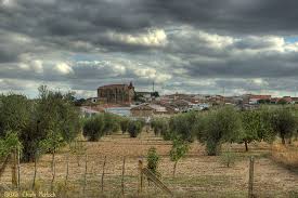
La Zarza se asienta junto a la Sierra del Calvario y muy próximo a la desembocadura del río Matachel en el río Guadiana, cerca de la presa de Alange. Si bien el municipio se encuentra a menos de 15 km en dirección sureste de Mérida, esta distancia se amplía por carretera a 26 km. Limita al norte con Villagonzalo, al este con Guareña y Oliva de Mérida, al sur con Alange y al oeste con los municipios de Mérida y Don Álvaro.

La situación del pueblo en la falda de la sierra, le hace tener calles de fuerte pendiente separándolo popularmente en dos zonas: la zona alta, más antigua, en donde residen los cabileños, y la zona más baja y moderna, morada de los chumberos.

Posiblemente el nombre de la localidad da fe de los muchos arbustos de ramas espinosas y dulces frutos de la familia de las rosáceas, las zarzas (Rubus ulmifolius), localizadas en las riberas de ríos y arroyos próximos al municipio.

En sus comienzos La Zarza fue llamada Zarza de Alange, dada su condición de aldea dependiente de este municipio limítrofe, en cuya encomienda se integraba. A lo largo del siglo XIX y principios del XX, el nombre fue oscilando alternativamente entre Zarza de Alange y Zarza junto a Alange tomando definitivamente la primera denominación desde el año 1910. No sería hasta el 20 de marzo de 1991 cuando La Zarza adquiere su actual nombre, por decreto publicado en el Diario Oficial de Extremadura, culminando de tal modo la vieja aspiración de autonomía de la población. En el presente, con 3.568 habitantes, resulta la población más importante de la comarca Tierra de Mérida – Vegas Bajas después de la capital, Calamonte y Arroyo de San Serván.

El pueblo es conocido en la comarca como “el pueblo de los dulces y las pieles”.

Naturaleza

En la solana de la Sierra de las Peñas Blancas, se encuentra una parcela municipal de 140.000m2, conocido como Sierra Utrera, donde podemos encontrar una notable variedad de especies de orquídeas, gracias principalmente a la conservación del espacio y a la diversidad de suelos de la zona. De hecho, de las 45 especies presentes en Extremadura, al menos la mitad se documenta aquí, ocupando distintos biotopos: laderas de sierra con matorral, dehesas arboladas con pastizal, riberas de ríos y arroyos, bancales de cultivo, etc.

De la gran variedad de orquídeas que crecen y florecen en primavera, hay que destacar la Serapiza perez-chiscanoi, en peligro de extinción por lo que Sierra Utrera fue declarada recientemente Lugar de Interés Científico debido a la población de esta especie.

RIO GUADIANA

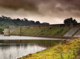
A tanto sólo 2 km de la localidad, el río Guadiana y su valle, baña las tierras zarceñas, albergando además numerosa fauna y flora, y regalándonos bellos lugares donde disfrutar de la naturaleza. Cabe destacar el puente de hierro o del ferrocarril hecho en 1865.

RIO MATACHEL

El río Matachel es uno de los afluentes más importantes del Guadiana y, en su paso por La Zarza, alberga distintos molinos que aprovechaban sus aguas para la molienda.

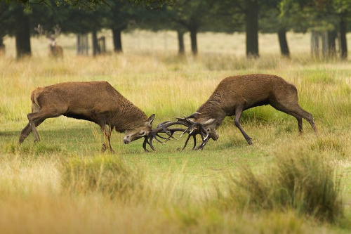
En sus aguas y riberas se puede encontrar fauna de muy elevado valor ecológico tales como el jarabugo, un pez endémico del Guadiana, y mamíferos como el meloncillo, la gineta y el gato montés, así como cigüeñas, garzas, rapaces, nutrias…

RUTA PEÑAS BLANCAS

El club de senderismo Peñas Blancas de La Zarza organiza desde hace años la Ruta de Peñas Blancas, un recorrido de 19 km de dificultad media que nos lleva por unos parajes increíbles e inesperados. Las panorámicas que nos ofrece la subida a la Sierra de Peñas Blancas o caminar por el valle de la Osa o Los Balancines y Sierra de Juan Bueno son añadidos a una ruta que nos descubre un pequeño valle situado entre sierras, desconocido para muchos, pero sorprendente.

Se combinan en el itinerario elementos muy importantes tanto del medio ambiente como parajes histórico artístico y etnográficos. A mitad de la ladera se encuentra La Cueva de la Calderita, perfectamente señalizada, donde encontramos pinturas rupestres, rastro de la presencia de los primeros pobladores de estas tierras. Al coronar la sierra, se observan las tierras de la Vega del Guadiana, en estos parajes, sobre todo, olivos y pastos. Además, al fondo, Mérida, la urbe romana; Alange, el pantano y su castillo. Es una paleta de colores que no te cansas de mirar. La imagen de una Extremadura, dedicada a la agricultura, que dibuja un paisaje de labranza. Al fondo dejamos este lugar para continuar por la falda de la Sierra de Las Molineras para coronar el Puerto de Las Hoyas y comenzar a descender por la umbría. La organización da la posibilidad de realizar una ruta alternativa sin subir a la sierra de 15 Km, optando a recorrer el camino más fácil adentrándose en el Valle de la Osa.
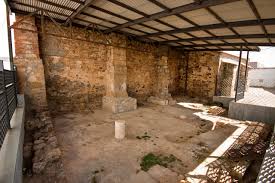
 PINTURAS RUPESTRES

Declarado Bien de Interés Cultural, el Abrigo de La Calderita se localiza a 2 km al suroeste de La Zarza, en la sierra de Peñas Blancas.

Se descubrió a mediados de la segunda década del siglo XX gracias a los trabajos de prospección de Henri Breuil y su incondicional acompañante Tomás Pareja.

Se trata de un conjunto del más puro estilo esquemático, tanto por la técnica utilizada como por las tipologías y temas representados. El abrigo está en una gran pared cuarcítica y supera los diez metros de longitud. Sus amplias superficies rocosas sirvieron como lienzo sobre el que se plasmaron varios centenares de figuras realizadas con pintura de color rojo y trazos continuos de diferentes grosores, combinando el uso de gruesos realizados con la yema del dedo para unas figuras y finos para otras; estos últimos realizados con pequeños pinceles o apliques de fibra vegetal o animal. Se combinan y asocian figuras de muy variados tipos.

Las pinturas se dividen en 5 grupos donde parecen figuras muy diversas dignas de ser visitadas: figuras masculinas y femeninas de tipo ramiforme (eje vertical cruzado por trazos horizontales, simulando tronco y extremidades respectivamente) y otras de tipo triangular (con dos o tres triángulos inversos y superpuestos). Entre las figuras zoomorfas se distribuyen por varios de los paneles distintos ejemplos de cuadrúpedos del tipo pectiniformes (un trazo horizontal y varios verticales, recordando a un peine). Los ideomorfos están representados por tectiformes (formas reticuladas que se asocian a mapas, construcciones o trampas), soliformes (sol), puntos y digitaciones.

MINAS

A lo largo del siglo XX y principios del XXI, la mina de ‘Juan Bueno’ pasó de explotarse artesanalmente por los tierrablanqueros a ser objeto de concesión minera, reflejado en los yacimientos ‘La Zarceña’ y ‘San Rafael’

Son Minas a cielo abierto situadas a 1,5 Km de la localidad, en el paraje conocido como Juan Bueno, por donde pasa un cordel de ganado que separa el final de la Sierra del Calvario del principio de la Sierra de los Barreros. El punto de partida es el edificio en ruinas de una antigua explotación de arcillas que se hallaba enclavado casi en el mismo puerto. Desde el punto de vista topográfico, la mina pasa por los senderos que van de La Zarza a Guareña y Oliva de Mérida. Se halla en la vertiente de aguas al arroyo de la Calera, afluente del río Matachel.

El caolín o tierrablanca se extraía laboriosa y penosamente a mano de los barreros y, posteriormente, se vendía por parte de la figura, ya casi mítica, del tierrablanquero acompañado de su burro por los pueblos de la comarca y la región para encalar las casas.

MOLINOS

La Zarza disfrutaba de 6 molinos harineros: dos en el Guadiana, y cuatro en el Matachel. 

El molino de la Rabia, es el molino mejor conservado de los que están situados en las orillas del rio Matachel.

Estuvo dotado de cinco pares de muelas, de las que conserva cuatro en su lugar original y otras reutilizadas a modo de pavimento. Está realizado en mampostería enfoscada combinada con ladrillos en los arcos. La cubierta es a dos aguas con bóvedas de cañón en el interior, realizada en ladrillo y también enfoscada. La longitud de la nave hace que sea el molino de mayor tamaño de los que hay alrededor y por ello fue necesaria la presencia de arcos fajones que refuerzan la bóveda de cañón, realizados también en ladrillos.

Existe una pequeña estancia, justo encima del cárcavo de la tercera pareja de muelas, dotada de una chimenea.

EL JARRO

Se encontró de forma fortuita por unos labradores en las afueras de La Zarza

Es un recipiente piriforme de bronce, cuyas dimensiones aproximadas son: 30 centímetros de altura, 12 de anchura máxima, casi un kilo y medio de peso y poco más de un litro de capacidad. 

En su morfología destaca la embocadura, en forma de cabeza de ciervo que, curiosamente, presenta embridado, como si de un caballo se tratara. La parte central del cuerpo se adorna con un baquetón, a lo que se suman dos palmetas en ambos extremos del asa, que falta casi completamente. 

El jarro de La Zarza data del siglo VII a.C. de la época de los Tartessos. Se halla en el museo arqueológico de Badajoz.

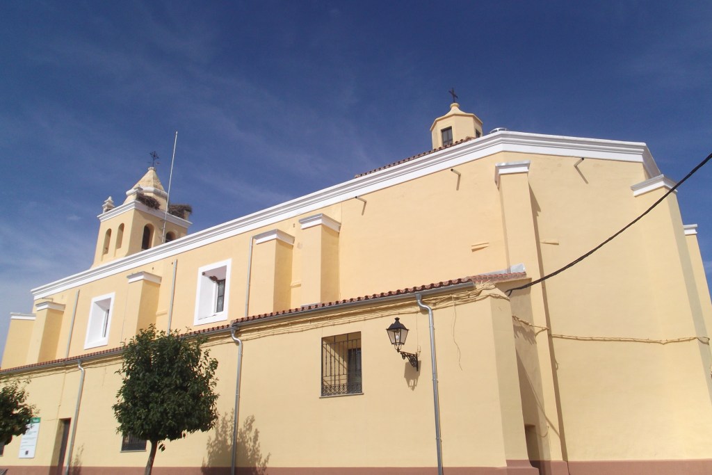
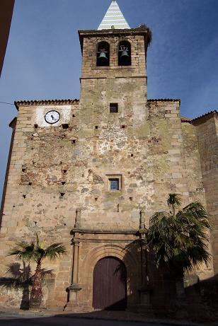
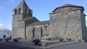
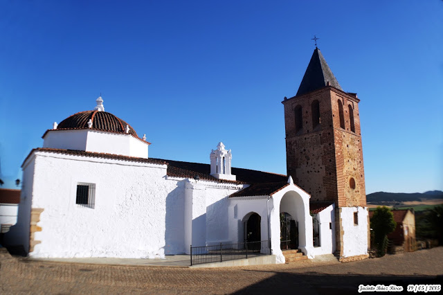
IGLESIA DE SAN MARTIN DE TOUS

Declarada Bien de Interés Cultural, está situada en la zona más alta del pueblo. En la edificación, originaria del siglo XVI se aprecian distintas etapas observándose así algunas diferencias formales entre la cabecera, poco más antigua, y la nave. Las dos portadas serían, a su vez, más tardías, probablemente del siglo XVII. Elemento de singular interés es la credencia u hornacina similar a otras que se pueden encontrar en la comarca de Mérida.

Se distribuye mediante planta de una sola nave, muy prolongada, con cabecera de grandes proporciones, y en tres tramos, además de atrio de entrada

La estructura exterior es de cajón.

La cabecera es de grandes proporciones y se estructura en dos ámbitos: el presbiterio y la capilla mayor, ambos cubiertos mediante bóveda de crucería estrellada sobre ménsulas y cabecera de ábside poligonal con cubierta de mismo tipo. Una pequeña sacristía y dos reducidas capillas se unen al cuerpo principal configurando la estructura de cruz latina.

Sobre el paño izquierdo del testero de la capilla mayor, aparece una hornacina-sagrario, enmarcada por una representación de portada de notable interés, ejecutada en piedra, siendo una obra de estilo renacentista, cuya elaborada filigrana tiene similitud a la dispuesta en la Iglesia Parroquial de la Candelaria de Fuente del Maestre. Formalmente se trata de un vano de arco carpanel con amplia banda decorada de grutescos, con escudo en la clave y pequeños medallones en las enjutas, flanqueado por finas columnillas.

ERMITA NUESTRA SEÑORA DE LAS NIEVES

Se encuentra situada en la parte baja de la localidad. Debe su nombre a la Patrona del pueblo ya que antiguamente estaba dedicada a los santos Mártires San Fabián y Sebastián. Es  de la primera mitad del siglo XVIII.

La ermita es una construcción de notables proporciones, en su interior presenta planta de cruz latina con nave dividida en 4 tramos y crucero cubierto de cúpula, detrás del cual se sitúa la sacristía y el camarín de la Virgen, cubierto también de cúpula, de manera que al exterior se manifiesta en una estructura de doble cimborrio ochavado.

Entre sus elementos más destacados está el camarín, el retablo mayor y el Carro de la Virgen.

En el camarín destacan las pinturas que cubren la cúpula, sus pechinas y los muros, restauradas a finales del siglo XX, con escenas del nacimiento de Jesús, huida a Egipto, Epifanía y otras. En las pechinas el Rey David y otros personajes Bíblicos. En la cúpula entre enmarques de estilo rococó aparecen 8 mujeres fuertes de la Biblia (Jael, Abigail, Esther, María, Judit, Sara, Deborah y Ruth).  En la cúpula del crucero destacan las pinturas al temple que lo cubren con escenas de la Coronación de la Virgen con blasonadas y ángeles. En las pechinas lienzos con diferentes escenas de la historia de la Virgen de las Nieves.

El atrio de la ermita, desde los años 40 a los 60 del pasado siglo era el lugar de encuentro de todos los jóvenes.
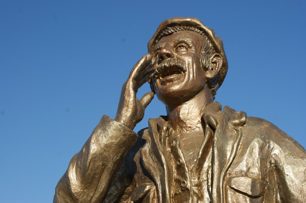
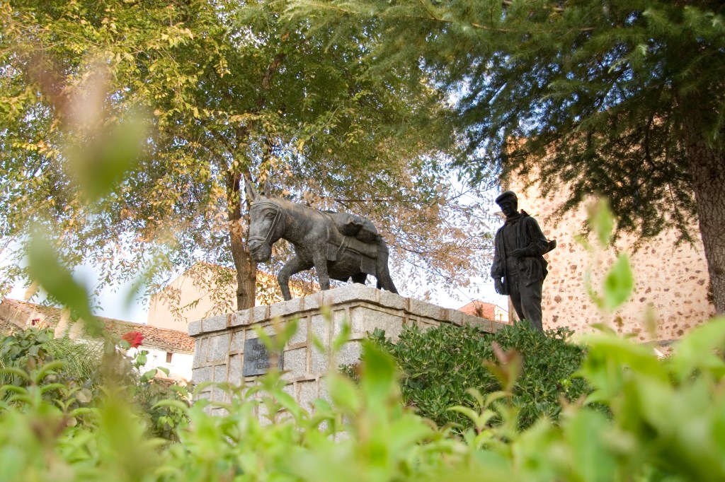
EL ARRIERO

Junto a la iglesia parroquial, obra en bronce realizada por el escultor Ricardo García, de Villanueva de la Serena, inaugurado en 1989. Consiste en un grupo compuesto por un asno y el popular “tierrablanquero”, o vendedor de tierrablanca o cal para enjalbegar las paredes, extraída de las minas de “Juanbueno”, ataviado con la típica chambra o blusón y llevando la romana al hombro.

EL PILAR

Antiguamente destinado a abrevadero, según el modelo tradicional, se conserva en la Plaza de España, restaurado y convertido en fuente.

EL EMIGRANTE

Se encuentra a la salida del pueblo, en Avda. de la Constitución, obra en bronce del escultor zarceño Javier Guerrero González-Piñero. Escultura de un emigrante de pie, con la vista vuelta hacia su pueblo y la maleta al lado.

EL BORRIQUERO

Pozo-abrevadero, con sus correspondientes pilones situado en el camino de Mérida. Es uno de los pozos más valorados, tanto por el agua, como por el servicio que antiguamente ofrecía a los vecinos. Alrededor del mismo, se encontraba una de las distintas eras del municipio. Tiene pilones a ambos lados. Está situado en el camino de Mérida. Hoy en día, es el lugar donde se celebra la subasta de la feria del ganado, a finales de abril o principios de mayo.

GASTRONOMIA

Son platos típicos de la localidad el ajo colorao y ajo blanco, las sopas de tomate, las tradicionales migas extremeñas, los peces de río asados o fritos, el pollo de corral con arroz o tomate y los huevos sucios.

Una gran variedad de repostería tradicional, destacando los bollos de chicharrones y hornazos, así como sus típicas roscas de hojaldre y pasteles elaborados con las recetas originarias en las pastelerías.

COMER Y BEBER

Mesón los Pajares

Avda. de Extremadura, 16. Tel: 924 366 860 

Mesón El Arriero

C/ Dulce Chacón, 4. Tel: 924 367 968 

Mesón Casa Lopez

C/ Mérida, s/n. Tel: 924 366 350 

Bar Restaurante El Pensaero

Pol. Industrial San Marcos. Tel: 924 367 372 

Bar Restaurante Punto y Coma

Pol. Industrial San Marcos. Tel: 658 612 700

Bar Restaurante El Centro

C/ Juan Andrés Valor, 19. Tel: 924 36 68 58

Bar Restaurante El Aderezo

Avda. Juan Carlos I. Tel: 924 71 01

Bar Restaurante La Veredilla

C/ La Veredilla, 8. Tel: 649 619 423

Bar Restaurante la Piscina

C/ Veredilla, 30. Tel: 626 375 470

Café-Bar Saturio

Plaza España. Tel: 924 36 62 26

Café-Bar Olimpo

C/ El Pilar, 6. Tel: 924 36 63 02

Café-Bar Corbacho

Plaza Ayuntamiento, 5. Tel: 924 36 75 52

Café-Bar La Parada

C/ Juan Andrés Valor. Tel: 924 36 69 05

Café-Bar La Peña

Travesía de San Martín, 6. Tel: 625 327 021

Bar Zarza

C/ Avda. Constitución. 

Café y Copas Noche Negra Pub

Avda. de Alange, 2. Tel: 620 811 029

Salón de celebraciones y eventos Selene

C/ Coso, 13. Tel: 624 36 60 44

Hotel Rural El Arriero

C/ Dulce Chacón, 4. Tlfno: 924 36 79 68

Casa Rural los Cortinales

Avda. Alange. Tlfno: 605 502 341

Hostal El Aderezo

Avda. Juan Carlos I. Tlfno: 722 368 757

Hostal Pensión Casa López

C/ Mérida, 1. Tlfno: 924 36 63 50 / 645 948

FIESTAS

Feria del Ganado. Feria de Mayo

  Finales de Abril y principios de Mayo

Fiesta Nuestra Sra. de las Nieves

  5 de Agosto

Feria Nuestra Sra. de las Nieves 

Feria de Septiembre

  Del 7 al 10 de Septiembre

San Isidro

  15 de Mayo

San Martín

  11 de Noviembre

Ruta de la Tapa

  Segundo fin de semana de marzo

Feria Multisectorial

  A primeros del mes de octubre

Vive la Calle

  A lo largo de 3 viernes de agosto

TELÉFONOS DE INTERÉS

Ayuntamiento: 924 36 60 01

Centro de Salud: 924 36 72 62 

Farmacia: 924 36 63 75 / 924 36 75 87

Policía Local: 608 924 842

Bomberos (Mérida): 924 37 28 61

Guardia Civil (Mérida):924 37 02 00

Autobuses (Mérida): 924 37 14 04

Taxi: 924 36 70 31

Hospital (Mérida): 924 38 10 00

La Zarza is located next to the mountain range Sierra del Calvario and very close to the place where the river Matachel flows into the Guadiana river,quite close to the reservoir of Alange. Only 15 Km far from Mérida, although this distance by road rises up to 26 km. It limits with Villagonzalo in the north, Guareña and Oliva de Mérida in the east, Alange in the south and Mérida or Don Álvaro in the west. 

As result of being located at the foot of the mountain, the streets of the village were built on steep slope which separate the town into two main areas: the upper area, where the original inhabitants -called cabileños– settled down, and the lowest and modern area, dwelt by the chumberos.

Likely the name of the village testifies the abundance of bushes of thorny branches and sweet fruits of the family of rosaceae, the brambles (Rubus ulmifolius), located on the banks of rivers and streams near the municipality.

Originally, La Zarza was called Zarza de Alange, due to its condition as a village dependent on this bordering municipality, in whose encomienda it was integrated. Throughout the nineteenth and early twentieth centuries, the name was alternately oscillating between Zarza de Alange and Zarza next to Alange. On  20th March 1991 La Zarza acquires its current name, by a decree published in the Official Gazette of Extremadura, thus culminating the old aspiration of independence from Alange. At present, with 3,568 inhabitants, it is the most important population in the region of Tierra de Mérida – Vegas Bajas.

The town is known in the region as «the town of sweets and fur”.

Nature

On the sunny side of Sierra de las Peñas Blancas, there is a local plot of 140.000m2, known as Sierra Utrera, where we can find a remarkable variety of orchid species, thanks mainly to the conservation of space and the diversity of soils in the area. In fact, at least half of the 45 species recorded in Extremadura, occupy different biotopes in this area: mountain slopes with scrub, meadows with pasture lands, banks of rivers and streams, arable benches, etc..

Serapiza perez-chiscanoi, an endangered species which blooms in spring, is the main reason for the declaration of Sierra de Utrera as Place of Scientific Interest.

GUADIANA RIVER   

Only 2 km away from the town, the Guadiana river bathes the lands of La Zarza, housing also numerous fauna and flora, and giving us beautiful places to enjoy nature. It is necessary to emphasize the bridge of iron of the railroad built in 1865.

MATACHEL RIVER 

The Matachel River is one of the most important tributaries of the Guadiana and, as it passes through La Zarza, it is home to several mills formerly used for milling.

Remarkable valued fauna such as the jarabugo, a fish endemic to the Guadiana, and mammals such as the meloncillo, the genet and wild cat, as well as storks, herons, birds of prey, otters among others can be found.

PEÑAS BLANCAS ROUTE

Peñas Blancas de La Zarza hiking club has been in charge of the organization of the Ruta de Peñas Blancas for years: a medium difficulty route consisting of 19 km takes us through incredible and unexpected places. The panoramic views offered by the ascent of the Sierra de Peñas Blancas or walking through the valley of the Osa or Los Balancines and Sierra de Juan Bueno are added to a route that discovers a small valley between mountains, unknown and surprising.

The route combines important environmental elements as well as historical, artistic and ethnographic stops. Halfway up the slope we reach La Cueva de la Calderita, perfectly signposted, where we find cave paintings, evidence of the first settlers. When crowning the mountain range, fertile lands full of olive trees and pasture lands at Vega del Guadiana are spotted. The Roman city of Mérida can be seen at the at the background, as well as Alange, the reservoir and its castle. Views continue along the slope of Sierra de Las Molineras to crown the Port of Las Hoyas and going down on the shady side. The organization offers the possibility of making an alternative route without climbing the 15 km mountain range, by the easiest way into the Osa Valley.

CAVE PAINTINGS

Declared Asset of Cultural Interest, Abrigo de La Calderita is located 2 km southwest of La Zarza, at Sierra de Peñas Blancas.

They were discovered by 1920’s thanks to the prospecting work of Henri Breuil and his unconditional assistant Tomás Pareja.

It is a set of the purest schematic style, both for the technique used and for the typologies and themes represented. The coat is on a large quartzite wall of more than ten metres long. Its wide rocky surfaces served as a canvas on which several hundred figures were captured, painted on red and continuous strokes of different thicknesses, combining thick -using fingertips for some figures- and fine -using small brushes or applications of vegetable fiber or animal- for others. Figures of many varied types are combined and associated.

The paintings are classified into 5 groups: masculine and feminine branch-shaped figures (upright axis crossed by horizontal lines, simulating trunk and extremities) and others of triangular shaped type (with two or three inverse and superimposed triangles). Among the zoomorphic figures distributed on the panels, different examples of quadrupeds of the pectiniformes type (a horizontal line and several vertical ones, similar to a comb). Ideomorphs are represented by tectiformes (reticulated forms associated with maps, constructions or traps), soliforms (sun), dots and fingering.

JUAN BUENO MINES  

Throughout the twentieth century and early twenty-first, the mine of ‘Juan Bueno’ was firstly handicraft tapped and later on, it was operated under mining extraction grant, reflected in the mine sites of ‘La Zarceña’ and ‘San Rafael’.

They are open-pit mines located 1.5 km from the town, at a place known as Juan Bueno, where a cord for cattle separates the end of Sierra del Calvario from the beginning of Sierra de los Barreros. The starting point is the ruined building of an old clay mine located almost in the same place. From a topographical point of view, the mine passes through the paths from La Zarza to Guareña and Oliva de Mérida. It is located on the watershed of the Calera stream, a tributary of the Matachel river.The kaolin or tierrablanca was laboriously and painfully handicraft extracted by the barreros and sold by the tierrablanqueros helped by their donkeys through the villages of the region. The product is typically used to whitewash the houses walls.

MILLS 

La Zarza held six flour mills: two by the Guadiana and the rest were located by the Matachel river. 

The Rabia mill is the best preserved of those located on the banks of the river Matachel.

It was endowed with five pairs of millstones, four of which remain in their original place and others were reused as part of the pavement. It is made of plastered masonry combined with bricks in the arches. The roof is gabled with barrel vaults inside, made of brick and also plastered. The length of the nave makes of it the largest mill in the surrounding area and for this reason it was necessary to build transverse arches for the reinforcement of the barrel vault, also made of bricks.

There is a small room equipped with a chimney just above the third pair of molars.

THE JARRO 

It was luckily found by some peasants on the outskirts of La Zarza.

It is a piriform bronze  30 centimeters high and 12 cm wide-container, of almost a kilo and a half of weight and around one litre-volume. 

Morphologically  the deer head-shaped embouchure stands out. The central part of the body is decorated with large bead moulding, two palmettes on the handle almost missing. 

The jug of La Zarza dates from the 7th century B.C. -from the time of the Tartessos. It is kept in the archaeological museum of Badajoz.

SAN MARTIN DE TOUS CHURCH

Declared an Asset of Cultural Interest, it is located in the upper side of the village. In the 16th century-building, different stages can be seen, thus observing some formal differences between the chancel, which is a bit older, and the nave. The two façades were posterior built, probably from the 17th century. An element of singular interest is the credence or niche similar to others found in the region of Merida.

It is distributed through a single large nave, with large head, in three sections, in addition to the atrium entrance.

The exterior shows rigid box structure.

The head of great proportions was planned in two areas: the presbytery and the main chapel, both covered by a star-shaped vault on corbels and the head of a polygonal apse with a similar roof. A small sacristy and two small chapels join the main body forming the Latin cross structure.

On the left panel of the main chapel, there is a niche-sagrary, framed by a representation of a façade of notable interest, executed in stone, being a work of Renaissance style, whose filigree is similar to the Parish Church of Candelaria de Fuente del Maestre. Formally, it is a carpanel arch span on a wide band decorated with grottoes, a shield in the keystone and small medallions in the spandrels, flanked by fine columns.

NUESTRA SEÑORA DE LAS NIEVES HERMITAGE

Dating from early 18th century, it is located in the lower part of the town. It is named after the patron saint of the village although it was formerly dedicated to the holy martyrs San Fabián and Sebastián. 

The hermitage is a notable proportions construction, with a Latin cross plan and a nave divided into 4 sections and transept covered with dome – the sacristy and the shrine of the Virgin are at the back, also covered with dome- resulting in a structure of double octagonal dome from outside.

Among its most outstanding elements are the dressing room, the main altarpiece and the Carro de la Virgen (Chariot of the Virgin).

In the dressing room there are paintings that cover the dome, its pendentives and the walls, which was restored at the end of the 20th century, with scenes of the birth of Jesus, flight into Egypt, Epiphany and others. In the pendentives, King David and other Biblical characters can be seen. In the dome between rococo style frames there are 8 strong women from the Bible (Jael, Abigail, Esther, María, Judit, Sara, Deborah and Ruth). In the dome of the transept, tempera paintings cover it with scenes of the Coronation of the Virgin emblazoned with angels. In the pendentives we can see canvases with different scenes from the history of the Virgen de las Nieves.

The atrium of the hermitage was the meeting place for all young people from the 1940s to the 1960s.

THE ARRIERO  

Next to the parish church, bronze work made by the sculptor Ricardo García, from Villanueva de la Serena, was inaugurated in 1989. It consists of a group of sculptures made up of a donkey and the popular tierrablanquero dressed with the typical chambra or blouse and carrying the scales on his shoulder.

THE BASIN 

Formerly used as watering place, according to the traditional model, it is preserved at Plaza de España, after restoration and reconvertion into a fountain.

THE EMIGRANT

It is located at the exit of the village, in Avda. de la Constitución, a bronze work by the Zarceño sculptor Javier Guerrero González-Piñero. The sculpture shows an emigrant standing, with the view back to his village and the suitcase next to it.

THE BORRIQUERO  

Watering place with its corresponding pylons on both sides located on the road to Merida. It is one of the most highly valued wells, both for the water and the service offered to its neighbours. Nowadays, it is the place where the auction of the livestock fair is held, at the end of April or beginning of May.

GASTRONOMY   

Coloured garlic and white garlic, tomato soups, the traditional migas extremeñas, river fish roasted or fried, poultry with rice or tomato and dirty eggs are typical dishes of the town.

There is a great variety of traditional pastries, such as crackling and hornazos buns, as well as the typical puff pastry rolls and cakes made with their original recipes in the bakeries.

WHERE TO EAT AND SLEEP

Mesón los Pajares

Avda. de Extremadura, 16. Tel: 924 366 860 

Mesón El Arriero

C/ Dulce Chacón, 4. Tel: 924 367 968 

Mesón Casa Lopez

C/ Mérida, s/n. Tel: 924 366 350 

Bar Restaurante El Pensaero

Pol. Industrial San Marcos. Tel: 924 367 372 

Bar Restaurante Punto y Coma

Pol. Industrial San Marcos. Tel: 658 612 700

Bar Restaurante El Centro

C/ Juan Andrés Valor, 19. Tel: 924 36 68 58

Bar Restaurante El Aderezo

Avda. Juan Carlos I. Tel: 924 71 01

Bar Restaurante La Veredilla

C/ La Veredilla, 8. Tel: 649 619 423

Bar Restaurante la Piscina

C/ Veredilla, 30. Tel: 626 375 470

Café-Bar Saturio

Plaza España. Tel: 924 36 62 26

Café-Bar Olimpo

C/ El Pilar, 6. Tel: 924 36 63 02

Café-Bar Corbacho

Plaza Ayuntamiento, 5. Tel: 924 36 75 52

Café-Bar La Parada

C/ Juan Andrés Valor. Tel: 924 36 69 05

Café-Bar La Peña

Travesía de San Martín, 6. Tel: 625 327 021

Bar Zarza

C/ Avda. Constitución. 

Café y Copas Noche Negra Pub

Avda. de Alange, 2. Tel: 620 811 029

Salón de celebraciones y eventos Selene

C/ Coso, 13. Tel: 624 36 60 44

Hotel Rural El Arriero

C/ Dulce Chacón, 4. Tlfno: 924 36 79 68

Casa Rural los Cortinales

Avda. Alange. Tlfno: 605 502 341

Hostal El Aderezo

Avda. Juan Carlos I. Tlfno: 722 368 757

Hostal Pensión Casa López

C/ Mérida, 1. Tlfno: 924 36 63 50 / 645 948

PARTIES     CORREGIDA

Cattle Fair. May Fair

  End of April and beginning of May

Festivity of Our Lady of the Snows

  August 5th

Our Lady of the Snows Fair 

September

  From 7th to 10th September

San Isidro

  May 15th

St. Martín

  November 11th

Route of the Tapa

  Second weekend of March

Multisectorial Fair

  At the beginning of October

Live the Street

  Throughout 3 Friday in August

CONTACT TELEPHONES 

Town Hall: 924 36 60 01

Health Centre: 924 36 72 62 

Chemistry: 924 36 63 75 / 924 36 75 87

Local Police: 608 924 842

Firefighters Station (Mérida): 924 37 28 61

Guardia Civil (Mérida):924 37 02 00

Bus Station (Mérida): 924 37 14 04

Taxi: 924 36 70 31

Hospital (Mérida): 924 38 10 00

El Carrascalejo

Iglesia de El Carrascalejo

La localidad de El Carrascalejo, municipio más pequeño de toda la región, se encuentra situada en las inmediaciones de Aljucén a 13 kilómetros de la capital extremeña, Mérida. Siendo paso de peregrinaje de la Vía de la Plata, también es “Senda de las Mesetas”. Pertenece a la comarca de tierras de Mérida- Vegas Bajas y el Partido Judicial de Mérida. Su ayuntamiento está formado por un concejo vecinal y un alcalde.

Fue fundado al amparo de la Carta de poblamiento otorgada a Mérida en 1235. Su nombre se hace derivar de la abundancia de carracas o matorrales de encinas existentes en la zona.

La Vía de la Plata a su paso por El Carrascalejo

La construcción de esta calzada romana supuso la edificación de núcleos urbanos conocidos como mansio, situados cada 25 millas romanas (unos 35 kilómetros aproximadamente). El trayecto estaba marcado, en millas romanas (1468 metros) con hitos de piedra llamados miliarios, muchos de los cuales se pueden ver aún en el recorrido.

Tras su puesta en valor, la Vía de la Plata, a su paso por Extremadura, vuelve a recuperar el protagonismo de antaño y se convierte en una opción cultural y turística para aquellos que deseen recorrer este camino.

Durante su recorrido por el territorio de la Mancomunidad, transcurre por zonas de gran riqueza medioambiental, nos lleva hasta Aljucén, atravesando los términos municipales de Mirandilla y El Carrascalejo.

En sus cercanías se sitúa la llamada Charca Grande, hermoso paraje natural y muy propicio para la pesca.

Iglesia

El templo parroquial de Nuestra Señora de la Consolación, se encuentra situado en el centro de la población. Se trata de una obra de la primera mitad del siglo XVI, es de una sola nave, dividida en dos tramos, el primero o absidal cubierto con cúpula de media naranja, y el segundo con cubierta de madera. La capilla mayor luce un precioso sagrario con arco conopial de piedra granítica de estilo plateresco. Los materiales empleados en su construcción son mampostería y sillares.

Al exterior podemos observar, su poderosa torre frontal, cuenta con cuerpo bajo de gran desarrollo y otro superior de campanas resuelto en ladrillo, con doble secuencia de vanos por la fachada

La portada de piedra granítica de fina labra se abre con arco carpanel con columnas sobre pedestal, donde luce una cruz con los símbolos pasión, obra de mediados del siglo XVI.

Gastronomía

Entre sus platos estrella encontramos la caldereta de cordero, tortilla de espárragos, la pringá, las migas, arroz patata y bacalao, puchas y pestiños.

Dónde comer y dormir

Apartamentos rurales, El Carrasca

Travesia de Mérida, 11.

06894, El Carrascalejo, Badajoz

Tel: 696 103 922

Casa rural Cancho Gordo

c/El Carrascalejo

06894, El Carrascalejo, Badajoz

Tel: 924 663 406/ 661 423 874

Albergue El Carrascalejo

c/ La Estación s/nº

06894, El Carrascalejo, Badajoz

Tel: 679 067 033/ 618 979 583

TELÉFONOS DE CONTACTO

Ayuntamiento: 924 31 63 60

Bomberos (Mérida): 924 372 861

Bomberos (Urgencia): 080

Cia.Sevillana de Electricidad (Mérida): 924 314 650

Guardia Civil (Mérida): 924 370 200 / 370 035

Hospital de Mérida: 924 381 000

Renfe (Mérida): 924 318 109

Autobuses (Mérida): 924 371 404

Taxi (Mérida): 924 309 026 / 309 036

Urgencias: 112

The village of El Carrascalejo, the smallest municipality in the region, is located nearby Aljucén -13 kilometres from the capital of Extremadura, Mérida-. The pilgrimage route Via de la Plata runs through the region from south to north, passing through El Carrascalejo, which is also «Senda de las Mesetas» (Path of the plateaus). It belongs to the region of Mérida- Vegas Bajas and the Judicial District of Mérida. Its council is formed by a neighborhood council and a mayor.

It was founded under the protection of the “Carta de poblamiento” granted to Mérida in 1235. Its name is derived from the abundance of rattles or bushes of holm oaks -Quercus ilex- in the area.

Way «Vía de la Plata» (Silver Route)

Construction of this Roman road meant also building the stops known as mansio, located every 25 Roman miles (about 35 km). The route was marked, in Roman miles (1468 meters) with stones called milestones, many of which can still be seen through the route.

After its enhancement, the Via de la Plata through Extremadura, recovers the previous protagonism and becomes a cultural and tourist option for those who wish to follow this route.

Along the route through our community of municipalities, the Way passes through areas of great environmental wealth, leading us to Aljucén, by the municipalities of Mirandilla and El Carrascalejo.

Nearby we can find the Charca Grande, a beautiful natural spot ideal for fishing.

The Parish Church

The parish church of Nuestra Señora de la Consolación is located in the centre of the village. It dates from the first half of the sixteenth century and consists of a single nave, divided into two sections: the first or apsidal is covered by a semicircular dome, and the second one which is covered with wood. The major chapel shows a precious tabernacle with a granite ogeel arch in plateresque style. The church is made from masonry and ashlars.

The powerful front tower seen from outside, consists of great low body and the top one of bells made from brick, with double sequence of bays or apertures through the facade.

The fine-worked granite stone entrance with a basket arch with columns on a pedestal, where a cross with passion symbols is shown, a work from the middle of the 16th century.

Gastronomy

Among their special dishes we find Lamb stew, asparagus omelette, pringá, breadcrumbs, rice potato and cod, portridge and pestiños.

Where to eat and sleep

Rural apartments, El Carrasca

Travesia de Mérida, 11.

06894, El Carrascalejo, Badajoz

Tel: 696 103 922

Cancho Gordo Cottage

El Carrascalejo Street

06894, El Carrascalejo, Badajoz

Tel: 924 663 406/ 661 423 874

El Carrascalejo Inn

Station Street

06894, El Carrascalejo, Badajoz

Tel: 679 067 033/ 618 979 583

Telephone contacts

Town Hall: 924 31 63 60

Firefighters (Mérida): 924 372 861

Firefighters (Emergency): 080

Electricity supply company (Mérida): 924 314 650

Guardia Civil (Mérida): 924 370 200 / 370 035

Hospital of Mérida: 924 381 000

Renfe – Train Station (Mérida): 924 318 109

Bus Station (Mérida): 924 371 404

Taxi (Mérida): 924 309 026 / 309 036

Emergency: 112

Don Álvaro

Iglesia de Don Álvaro

Historia de Don Álvaro

Tras la reconquista de la Comarca de Mérida por las armas leonesas, ésta pasa a estar administrada por la Orden de Santiago, existiendo una gran preocupación por repoblar estos territorios conquistados. La localidad de Don Álvaro nace en este contextos, familias que vivían en los aledaños de la ermita de San Bernabé y la desaparecida de San Benito y en los cerros de El Cuarto y Las Cuestas, se agrupan dando lugar a la actual localidad, que recibirá su nombre del Gran Maestre de la Orden de Santiago, Don Álvaro de Luna. Se independiza de Mérida en 1593. 

Naturaleza

Don Álvaro se encuentra entre montes, dehesas y vías fluviales. Cabe destacar el “Paraje de la Junta”, donde confluyen los ríos Matachel y Guadiana, con zonas de pesca del barbo común, carpa y lucio.

Destacan los paisajes de encinas, jaras y retamas. En ellos hay pequeños cotos de caza menor, donde abundan las liebres y las perdices. Si miramos al cielo, podemos observar abejarucos, cigüeñas, golondrinas y gran variedad de pájaros que atraen a los amantes de la ornitología, tanto en la orilla del río como en los pastizales.

Gastronomía

La gastronomía a destacar de la zona es:

Platos fríos como el gazpacho y sopas variadas.

Guisos de cordero, asados, cocidos o estofados también forman parte de la riqueza culinaria alvarense así como los productos derivados del cerdo: jamones, chorizo, lomo…

Como dulce típico propio, las roscas de bolsillo.

RUTAS SENDERISTAS

Ruta los Molinos 

Esta ruta se realiza de noche y en la estación veraniega, sin fecha concreta.

Decir que esta población cuenta con una asociación senderista llamada “La Dehesa”, la cual es la encargada de organizar este evento.

MONUMENTOS

Iglesia parroquial de Santa María Magdalena

La obra, originaria de finales del siglo XV, fue construida por la Orden de Santiago. El templo conserva dos ábacos tallados en mármol; uno de ellos es la pila bautismal.

Distinguir en particular la ochavada cúpula de la cabecera, la portada porticada del lado del evangelio y la poderosa torre de mampostería y ladrillo.

Reducido el espacio interior,se articula sobre una sola nave de cuatro tramos sobre arcos apuntados de ladrillos vistos, con cubierta de fábrica que sustituye a la original de madera.

Molinos harineros

Se localizan en el término del pueblo y junto al río Guadiana.

a uno de los molinos se le conoce como “El Molino de la Dehesa” y el otro es “ El Molino de la Aceña”, restaurado hace unos años.

Ermita San Bartolomé

Está situada a 2 km del pueblo, data del siglo XIII dedicada a la advocación de San Bernabé en cuyo retablo está su talla en madera policromada (siglo XVI).

Posee un bello altar de azulejos de finales del siglo XV (imagen de la portada).

Arquitectura popular

La arquitectura se caracteriza por calles adoquinadas y estrechas.

Casa con fachadas variadas y escasas edificaciones altas.

Amplios patios.

Piedras de sangre

Situadas en el camino de San Bernabé, de color rojizo.

Cuenta la leyenda que aquí murió desangrado el santo y las marcas las hicieron sus animales que le acompañaban

Fuente del pilar

Se localiza a la entrada de la localidad accediendo por la carretera de Mérida, ya en uso en el siglo XVIII. Se desconoce la procedencia de su manantial, siendo una fuente inagotable de agua. Junto a ella se encuentra el antiguo lavadero municipal.

Dónde comer y dormir

Café Bar Mª José

Pl. de España, 6 / 924 367 509

Café Bar Candy

Pl. de España, 14 / 924 366 488

Mesón La Bodega

Crta. de la Estación, 11 / 691 356 047

La tijera, Complejo hostelero

Crta. Don Álvaro, Km 4 / 924 123 236 / 675 989 569

Rino’s Pub / 660 615 816

Casa rural Quinta del Triario 

(categoría 2 encinas)

Casa rural aislada e inspirada en una casa romana.

Dehesa de Berbén, 1 / 669 607 835

http://www.casaruralromana.com / triario@casaruralromana.com

Casa rural Don Álvaro de Luna 

(categoría 2 encinas)

C/Juan Carlos I, 43 / 924 361 08 1/ 608 026 138

info@casaruraldonalvarodeluna.es

Teléfonos de interés

Ayuntamiento: 924 36 69 01

C.e.i.y Gimnasio Municipal: 924 36 69 01

Residencia y Centro de Día: 676 991 696

C.e.i.p. Pío Xi: 924 02 45 62

Consultorio Médico: 924 366 435

Farmacia: 924 366 923

Renfe (Mérida): 924 318 109

Autobuses (Mérida): 924 371 404

Taxi (Mérida): 924 309 026 / 309 036

Urgencias: 112

Fiestas

Las Candelas 

2 de Febrero

Fiesta de la Sta. Cruz de Mayo

3 de Mayo

Fiesta de San Bernabé

11 de Junio, Patrón de La Villa

Fiesta de Sta. Mª Magdalena

22 de Julio

History of Don Álvaro

After the reconquest of the Region of Merida by the Leonese army, it was under the administration by the Order of Santiago, existing a great preoccupation to repopulate these conquered territories. The locality of Don Álvaro was born in this context, families who lived in the vicinity of the hermitage of San Bernabé and the disappeared one of San Benito and in the hills of El Cuarto and Las Cuestas, were grouped giving rise to the present locality, which received its name from the Grand Master of the Order of Santiago, Don Álvaro de Luna. It became independent from Merida in 1593.

Nature

Don Álvaro is located between mountains, meadows and waterways. It is worth mentioning the «Paraje de la Junta», where the rivers Matachel and Guadiana converge, with fishing areas for common barbel, carp and pike.

The landscapes of holm oaks, rockrose and brooms stand out. In them there are small preserved areas, where hares and partridges are abundant. If we look at the sky, we can observe bee-eaters, storks, swallows and a great variety of birds that attract ornithology lovers, both on the banks of the river and in the pastures.

Gastronomy

The gastronomy to emphasize of the zone is:

Cold dishes such as gazpacho and varied soups.

Lamb stews, roasts, stews or stews are also part of the culinary richness of Alvarado as well as products derived from pork: hams, chorizo, loin …

As a typical sweet, the roscas de bolsillo.

HIKING TRAILS

Los Molinos Route 

This route is done at night and in the summer season, with no specific date.

To say that this town has a walking association called «La Dehesa», which is responsible for organizing this event.

MONUMENTS

Parish Church of Santa María Magdalena

The work, original from the end of the 15th century, was built by the Order of Santiago. The temple conserves two abacuses carved in marble; one of them is the baptismal font.

Particularly noteworthy are the octagonal dome at the head, the porticoed portal on the gospel side and the powerful masonry and brick tower.

Once the interior space is reduced, it is articulated on a single nave with four sections on pointed arches of exposed bricks, with a factory roof that replaces the original wooden one.

Flour Mills

They are located in the town and next to the Guadiana river.

One of the mills is known as «El Molino de la Dehesa» and the other is «El Molino de la Aceña», restored a few years ago.

San Bartolomé Hermitage

It is located 2 km from the village, dating from the thirteenth century dedicated to the dedication of St. Barnabas in whose altarpiece is his polychrome wood carving (sixteenth century).

It has a beautiful altar of tiles from the late fifteenth century (image of the cover).

Popular architecture

The architecture is characterized by narrow cobbled streets.

House with varied facades and few high buildings.

Spacious courtyards.

Stones of blood

Placed in the way of San Bernabé, of reddish color.

Legend has it that the saint bled to death here and the marks were made by his accompanying animals.

Pillar source

It is located at the entrance to the town, accessed by the Mérida road, which was already in use in the 18th century. The origin of its spring is unknown, being an inexhaustible source of water. Next to it is the old municipal washing place.

Where to eat and sleep

Café Bar Mª José

Pl. of Spain, 6 / 924 367 509

Café Bar Candy

Pl. de España, 14 / 924 366 488

Mesón La Bodega

Crta. de la Estación, 11 / 691 356 047

La tijera, Hotel complex

Crta Don Álvaro, Km 4 / 924 123 236 / 675 989 569

Rino’s Pub / 660 615 816

Rural house Quinta del Triario 

(category 2 holm oaks)

Isolated rural house inspired by a Roman house.

Dehesa de Berbén, 1 / 669 607 835

http://www.casaruralromana.com / triario@casaruralromana.com

Rural house Don Álvaro de Luna 

(category 2 holm oaks)

C/Juan Carlos I, 43 / 924 361 08 1/ 608 026 138

info@casaruraldonalvarodeluna.es

Parties

The Candelas 

February 2nd

Feast of the Holy Cross of May

May 3rd

Feast of Saint Barnabas

June 11, Patron Saint of La Villa

Feast of St. Mary Magdalene

July 22nd

Aljucén

Aljucén

Historia de Aljucén

La fundación de Aljucén se estima musulmana, según evidencia su nombre, vocablo árabe que significa castillejo o del río cercano denominado en aquella época El Junciel (por las juncias existentes).

Se acoge también al trazado de la antigua Vía de la Plata hacia el norte de Mérida, asentándose junto al río de su mismo nombre. Sobre éste se alzaba un puente romano de tres arcos hoy ya desaparecido.

Naturaleza en Aljucén

En el tramo que une Aljucén a Mérida, y jalonando los márgenes del Río Aljucén, se conservan restos de la vegetación de ribera característica de la cuenca del Guadiana, con bosquetes de fresnos, álamos, sauces y mimbreras, y rodales de adelfas y atarfes.

Estos sotos albergan una interesante comunidad faunística, asociada al medio ribereño, cuyos elementos más llamativos son las aves. La más representativa es la Garcilla Bueyera, que anida en nutridas colonias en los islotes del embalse, haciendo blanquear los árboles en la época de cría. Pueden observarse también ánades, fochas, pollas de agua, gaviotas, cormoranes y otras muchas aves acuáticas.

Aljucén se encuentra dentro del perímetro del Parque Natural de Cornalvo, un lugar protegido, un oasis en cierta medida que tiene la función de preservar los ecosistemas y los ritmos naturales.

En este espacio abundan las dehesas de encinas y de alcornocales, a excepción de la vegetación de ribera, que se conserva en las orillas del río Aljucén y los arroyos del Muelas, de la Fresneda o del propio Albarregas.

La Vía de la Plata a su paso por Aljucén

El pueblo de Aljucén está incluído en el recorrido de la Vía de la Plata romana, que luego fue el camino sur de peregrinación a Santiago de Compostela.

La Vía de la Plata era una calzada romana que atravesaba la parte oeste de la península de norte a sur. Su nombre, curiosamente, no deriva del precioso metal, sino de la palabra árabe «balat», que significa camino empedrado.

El trazado de la Vía de la Plata transita a través de un corredor natural entre Mérida y Astorga, que ya utilizaban los pueblos prerromanos para comerciar con el sur de la Península. Fue más tarde, durante la época de dominación romana, cuando se construyó la calzada que uniría ambas ciudades, y que luego se ampliaría hasta llegar a Sevilla por el sur y a Gijón por el norte.

Ruta del Cordel del Cerro del Gato

Un recorrido fluvial siguiendo el curso del río Aljucén a lo largo de 7 kilómetros de longitud.

Iglesia Parroquial De San Andrés Apostol

Fue construida por la Orden de Santiago entre los siglos XV y XVI bajo la advocación de San Andrés Apóstol, patrono del pueblo.

Destaca la portada renacentista orientada al Oeste, de gran belleza y elegancia, la cual está coronada por dos medallones que representan a Santiago Apóstol y a San Andrés Apóstol, con sus respectivas cruces.

Se trata de una iglesia de pequeñas dimensiones, con una única nave edificada en mampostería y sillares de piedra dividida en dos tramos, planta de cruz latina con bóveda estrellada, y una torre que es la prolongación de la fachada.

Lavadero

Desde hace unos años se trabaja en la recuperación del antiguo lavadero y su entorno, acondicionado para poder ser visitable, permitiendo hacerse una idea de cómo era su funcionamiento.

En torno al Lavadero, se esta habilitando una zona de arboleda, aparcamiento y merendero para disfrute de vecinos y peregrinos.

Los Pozos

Existen en la localidad dos pozos comunitarios que antaño abastecían de agua a los vecinos de la localidad. 

Se ha procedido a su recuperación y puesta en valor para que sean visitables.

El pozo de La Abuela y el pozo Calle Nueva.

Zona de Recreo

En el tramo del río Aljucén que transcurre por la localidad hay acondicionada una zona de recreo, con un área de juegos infantiles, mesas, bancos, barbacoas, que permite disfrutar de un entorno natural privilegiado.

Fiestas de Aljucén

FIESTA DEL EMIGRANTE: Se celebra el fin de semana siguiente al día 15 de agosto.

FIESTA PATRONAL DE SAN ANDRÉS: Ultimo fin de semana de noviembre.

DOMINGO DE RESURRECCIÓN: Romería de la confraternidad organizada por los 3 municipios limítrofes de Aljucén, El Carrascalejo y Mirandilla.

ROMERÍA: Conocida popularmente como “la fuente de la peseta”, que se celebra el primer domingo de mayo.

Gastronomía

La gastronomía típica está representada por platos fríos; ya sean gazpachos al estilo extremeño, sopa de tomate, sopa de ajo, ensaladas de lechuga y tomate, junto a suculentos preparados a base de cordero: caldereta de cordero, cordero estofado, o cordero asado.

Dónde comer y dormir en Aljucén

ALBERGUE RIO ALJUCEN

C/ Santiago de Compostela, 2 Aljucén (Badajoz)

Tfnos: 924349456 – 695171383

www.alberguerioaljucen.com

HOTEL RURAL AQUA LIBERA

C/ Cáceres, 26 Aljucén (Badajoz)

Tfnos: 924310032 – 667520190

www.aqualibera.com 

CASA RURAL MERIDA

Avda. de Extremadura,8 Aljucén (Badajoz)

Tfno: 657382901

www.casaruralmerida.com

Teléfonos de interés

Ayuntamiento: 924 31 69 01

Urgencias: 112

Bomberos: 080

Taxi (Mérida): 924309026

History of Aljucén

The origin of Aljucén dates from Muslim period in the Iberian Peninsula, whose present name comes from the Moslem «Al-Huṣayn», that means «the scaffolding», little fortress although it might have been named after the nearby river formerly called El Junciel (by the presence of sedges).

It is also located on the route of the old Via de la Plata, settled next to its namesake river. Above it, a Roman bridge was built with three arches nowadays disappeared.

Nature

In the section that joins Aljucén to Mérida, along the banks of Aljucén River, characteristic riverside vegetation of the Guadiana basin are preserved, with small woods of ash trees, poplars, willows and crack willow and brambles, and stands of oleanders and tamarisks.

These groves are home to an interesting fauna community, associated with the riverside environment, where birds are the most striking elements. The most representative is the Cattle Egret which nests in nourished colonies on the islets of the reservoir, whitening the trees during the breeding season. There are also ducks, coots, water cocks, seagulls, cormorants and many other aquatic birds.

Aljucen is located within the perimeter of Cornalvo Natural Park, a protected oasis for the preservation of ecosystems and natural rhythms.

In this area Holm oaks and cork oak are abundant, except for the riverside vegetation, which is preserved on the banks of the river Aljucén and the streams of Muelas, Fresneda or Albarregas.

Via de la Plata

The village of Aljucén is part of the Roman Silver Route, which later became the southern pilgrimage route to Santiago de Compostela.

The Silver Route was a Roman road which crossed the western part of the Iberian Peninsula from north to south. It is not named after the precious metal, but from the Arabic word «balat», which means paved road.

Via de la Plata runs through a natural corridor between Mérida and Astorga, already used by the pre-Roman towns to trade with the south of the Peninsula. It was later, during the Roman domination period, when the road linking the two cities was built, which would later be extended to Seville in Andalusia -to the south- and Gijón in Asturias -to the north-.

Route “Cerro del Gato”

A fluvial route following the course of the river Aljucén along 7 kilometers.

Parish Church Of San Andres Apostol

It was built by the Order of Santiago between the fifteenth and sixteenth centuries dedicated to St. Andrew the Apostle, patron saint of the town.

Renaissance doorway facing west, beautiful and elegant, is crowned by two medallions representing Saint James the Apostle and Saint Andrew the Apostle, with their respective crosses.

It is a small church, with a single nave built in masonry and stone ashlars divided into two sections. It has a Latin cross plan with a vault with star motifs, and a tower which is an extension of the doorway.

The Laundry

Reconstruction works on the old public laundry and surroundings allow the visitors imagine the former function of the place. 

Grove, car park and picnic area are being installed around the old public laundry for the enjoyment of neighbours and pilgrims.

Wells

Two community wells were used to supply water to the locals. 

Nowadays they have been rebuilt and revalued for the tourists to visit them.

Grandma’s well and New Street well.

Leisure area

Along the stretch of the Aljucén river that runs through the town there is a recreation area, playground, tables and barbecue for the enjoyment of this stunning natural environment.

Parties

PARTY OF THE EMIGRANT: Held on the following weekend after August 15th.

SAINT ANDREW PARTY: Last weekend of November.

EASTER SUNDAY: Pilgrimage for the fraternity organized by Aljucén, El Carrascalejo and Mirandilla.

ROMERIA: Popularly known as «la fuente de la peseta», which is held on the first Sunday of May.

Gastronomy

The typical gastronomy is represented by cold dishes, whether gazpachos in Extremadura style, tomato soup, garlic soup, lettuce and tomato salads, as well as succulent dishes made from lamb like lamb stew or roast lamb.

Where to sleep and eat

RIO ALJUCEN INN

C/ Santiago de Compostela, 2 Aljucén (Badajoz)

Tfnos: 924349456 – 695171383

www.alberguerioaljucen.com

AQUA LIBERA RURAL HOTEL

C/ Cáceres, 26 Aljucén (Badajoz)

Tfnos: 924310032 – 667520190

www.aqualibera.com 

MERIDA RURAL GUESTHOUSE

Avda. de Extremadura,8 Aljucén (Badajoz)

Tfno: 657382901

www.casaruralmerida.com

Contact telephones

Town Hall: 924 31 69 01

Emergency: 112

Firefighters: 080

Taxi (Mérida): 924309026

Diseña un sitio como este con WordPress.com
Comenzar