La Zarza se asienta junto a la Sierra del Calvario y muy próximo a la desembocadura del río Matachel en el río Guadiana, cerca de la presa de Alange. Si bien el municipio se encuentra a menos de 15 km en dirección sureste de Mérida, esta distancia se amplía por carretera a 26 km. Limita al norte con Villagonzalo, al este con Guareña y Oliva de Mérida, al sur con Alange y al oeste con los municipios de Mérida y Don Álvaro.
La situación del pueblo en la falda de la sierra, le hace tener calles de fuerte pendiente separándolo popularmente en dos zonas: la zona alta, más antigua, en donde residen los cabileños, y la zona más baja y moderna, morada de los chumberos.
Posiblemente el nombre de la localidad da fe de los muchos arbustos de ramas espinosas y dulces frutos de la familia de las rosáceas, las zarzas (Rubus ulmifolius), localizadas en las riberas de ríos y arroyos próximos al municipio.
En sus comienzos La Zarza fue llamada Zarza de Alange, dada su condición de aldea dependiente de este municipio limítrofe, en cuya encomienda se integraba. A lo largo del siglo XIX y principios del XX, el nombre fue oscilando alternativamente entre Zarza de Alange y Zarza junto a Alange tomando definitivamente la primera denominación desde el año 1910. No sería hasta el 20 de marzo de 1991 cuando La Zarza adquiere su actual nombre, por decreto publicado en el Diario Oficial de Extremadura, culminando de tal modo la vieja aspiración de autonomía de la población. En el presente, con 3.568 habitantes, resulta la población más importante de la comarca Tierra de Mérida – Vegas Bajas después de la capital, Calamonte y Arroyo de San Serván.
El pueblo es conocido en la comarca como “el pueblo de los dulces y las pieles”.
Naturaleza
En la solana de la Sierra de las Peñas Blancas, se encuentra una parcela municipal de 140.000m2, conocido como Sierra Utrera, donde podemos encontrar una notable variedad de especies de orquídeas, gracias principalmente a la conservación del espacio y a la diversidad de suelos de la zona. De hecho, de las 45 especies presentes en Extremadura, al menos la mitad se documenta aquí, ocupando distintos biotopos: laderas de sierra con matorral, dehesas arboladas con pastizal, riberas de ríos y arroyos, bancales de cultivo, etc.
De la gran variedad de orquídeas que crecen y florecen en primavera, hay que destacar la Serapiza perez-chiscanoi, en peligro de extinción por lo que Sierra Utrera fue declarada recientemente Lugar de Interés Científico debido a la población de esta especie.
RIO GUADIANA
A tanto sólo 2 km de la localidad, el río Guadiana y su valle, baña las tierras zarceñas, albergando además numerosa fauna y flora, y regalándonos bellos lugares donde disfrutar de la naturaleza. Cabe destacar el puente de hierro o del ferrocarril hecho en 1865.
RIO MATACHEL
El río Matachel es uno de los afluentes más importantes del Guadiana y, en su paso por La Zarza, alberga distintos molinos que aprovechaban sus aguas para la molienda.
En sus aguas y riberas se puede encontrar fauna de muy elevado valor ecológico tales como el jarabugo, un pez endémico del Guadiana, y mamíferos como el meloncillo, la gineta y el gato montés, así como cigüeñas, garzas, rapaces, nutrias…
RUTA PEÑAS BLANCAS
El club de senderismo Peñas Blancas de La Zarza organiza desde hace años la Ruta de Peñas Blancas, un recorrido de 19 km de dificultad media que nos lleva por unos parajes increíbles e inesperados. Las panorámicas que nos ofrece la subida a la Sierra de Peñas Blancas o caminar por el valle de la Osa o Los Balancines y Sierra de Juan Bueno son añadidos a una ruta que nos descubre un pequeño valle situado entre sierras, desconocido para muchos, pero sorprendente.
Se combinan en el itinerario elementos muy importantes tanto del medio ambiente como parajes histórico artístico y etnográficos. A mitad de la ladera se encuentra La Cueva de la Calderita, perfectamente señalizada, donde encontramos pinturas rupestres, rastro de la presencia de los primeros pobladores de estas tierras. Al coronar la sierra, se observan las tierras de la Vega del Guadiana, en estos parajes, sobre todo, olivos y pastos. Además, al fondo, Mérida, la urbe romana; Alange, el pantano y su castillo. Es una paleta de colores que no te cansas de mirar. La imagen de una Extremadura, dedicada a la agricultura, que dibuja un paisaje de labranza. Al fondo dejamos este lugar para continuar por la falda de la Sierra de Las Molineras para coronar el Puerto de Las Hoyas y comenzar a descender por la umbría. La organización da la posibilidad de realizar una ruta alternativa sin subir a la sierra de 15 Km, optando a recorrer el camino más fácil adentrándose en el Valle de la Osa.
PINTURAS RUPESTRES
Declarado Bien de Interés Cultural, el Abrigo de La Calderita se localiza a 2 km al suroeste de La Zarza, en la sierra de Peñas Blancas.
Se descubrió a mediados de la segunda década del siglo XX gracias a los trabajos de prospección de Henri Breuil y su incondicional acompañante Tomás Pareja.
Se trata de un conjunto del más puro estilo esquemático, tanto por la técnica utilizada como por las tipologías y temas representados. El abrigo está en una gran pared cuarcítica y supera los diez metros de longitud. Sus amplias superficies rocosas sirvieron como lienzo sobre el que se plasmaron varios centenares de figuras realizadas con pintura de color rojo y trazos continuos de diferentes grosores, combinando el uso de gruesos realizados con la yema del dedo para unas figuras y finos para otras; estos últimos realizados con pequeños pinceles o apliques de fibra vegetal o animal. Se combinan y asocian figuras de muy variados tipos.
Las pinturas se dividen en 5 grupos donde parecen figuras muy diversas dignas de ser visitadas: figuras masculinas y femeninas de tipo ramiforme (eje vertical cruzado por trazos horizontales, simulando tronco y extremidades respectivamente) y otras de tipo triangular (con dos o tres triángulos inversos y superpuestos). Entre las figuras zoomorfas se distribuyen por varios de los paneles distintos ejemplos de cuadrúpedos del tipo pectiniformes (un trazo horizontal y varios verticales, recordando a un peine). Los ideomorfos están representados por tectiformes (formas reticuladas que se asocian a mapas, construcciones o trampas), soliformes (sol), puntos y digitaciones.
MINAS
A lo largo del siglo XX y principios del XXI, la mina de ‘Juan Bueno’ pasó de explotarse artesanalmente por los tierrablanqueros a ser objeto de concesión minera, reflejado en los yacimientos ‘La Zarceña’ y ‘San Rafael’
Son Minas a cielo abierto situadas a 1,5 Km de la localidad, en el paraje conocido como Juan Bueno, por donde pasa un cordel de ganado que separa el final de la Sierra del Calvario del principio de la Sierra de los Barreros. El punto de partida es el edificio en ruinas de una antigua explotación de arcillas que se hallaba enclavado casi en el mismo puerto. Desde el punto de vista topográfico, la mina pasa por los senderos que van de La Zarza a Guareña y Oliva de Mérida. Se halla en la vertiente de aguas al arroyo de la Calera, afluente del río Matachel.
El caolín o tierrablanca se extraía laboriosa y penosamente a mano de los barreros y, posteriormente, se vendía por parte de la figura, ya casi mítica, del tierrablanquero acompañado de su burro por los pueblos de la comarca y la región para encalar las casas.
MOLINOS
La Zarza disfrutaba de 6 molinos harineros: dos en el Guadiana, y cuatro en el Matachel.
El molino de la Rabia, es el molino mejor conservado de los que están situados en las orillas del rio Matachel.
Estuvo dotado de cinco pares de muelas, de las que conserva cuatro en su lugar original y otras reutilizadas a modo de pavimento. Está realizado en mampostería enfoscada combinada con ladrillos en los arcos. La cubierta es a dos aguas con bóvedas de cañón en el interior, realizada en ladrillo y también enfoscada. La longitud de la nave hace que sea el molino de mayor tamaño de los que hay alrededor y por ello fue necesaria la presencia de arcos fajones que refuerzan la bóveda de cañón, realizados también en ladrillos.
Existe una pequeña estancia, justo encima del cárcavo de la tercera pareja de muelas, dotada de una chimenea.
EL JARRO
Se encontró de forma fortuita por unos labradores en las afueras de La Zarza
Es un recipiente piriforme de bronce, cuyas dimensiones aproximadas son: 30 centímetros de altura, 12 de anchura máxima, casi un kilo y medio de peso y poco más de un litro de capacidad.
En su morfología destaca la embocadura, en forma de cabeza de ciervo que, curiosamente, presenta embridado, como si de un caballo se tratara. La parte central del cuerpo se adorna con un baquetón, a lo que se suman dos palmetas en ambos extremos del asa, que falta casi completamente.
El jarro de La Zarza data del siglo VII a.C. de la época de los Tartessos. Se halla en el museo arqueológico de Badajoz.
IGLESIA DE SAN MARTIN DE TOUS
Declarada Bien de Interés Cultural, está situada en la zona más alta del pueblo. En la edificación, originaria del siglo XVI se aprecian distintas etapas observándose así algunas diferencias formales entre la cabecera, poco más antigua, y la nave. Las dos portadas serían, a su vez, más tardías, probablemente del siglo XVII. Elemento de singular interés es la credencia u hornacina similar a otras que se pueden encontrar en la comarca de Mérida.
Se distribuye mediante planta de una sola nave, muy prolongada, con cabecera de grandes proporciones, y en tres tramos, además de atrio de entrada
La estructura exterior es de cajón.
La cabecera es de grandes proporciones y se estructura en dos ámbitos: el presbiterio y la capilla mayor, ambos cubiertos mediante bóveda de crucería estrellada sobre ménsulas y cabecera de ábside poligonal con cubierta de mismo tipo. Una pequeña sacristía y dos reducidas capillas se unen al cuerpo principal configurando la estructura de cruz latina.
Sobre el paño izquierdo del testero de la capilla mayor, aparece una hornacina-sagrario, enmarcada por una representación de portada de notable interés, ejecutada en piedra, siendo una obra de estilo renacentista, cuya elaborada filigrana tiene similitud a la dispuesta en la Iglesia Parroquial de la Candelaria de Fuente del Maestre. Formalmente se trata de un vano de arco carpanel con amplia banda decorada de grutescos, con escudo en la clave y pequeños medallones en las enjutas, flanqueado por finas columnillas.
ERMITA NUESTRA SEÑORA DE LAS NIEVES
Se encuentra situada en la parte baja de la localidad. Debe su nombre a la Patrona del pueblo ya que antiguamente estaba dedicada a los santos Mártires San Fabián y Sebastián. Es de la primera mitad del siglo XVIII.
La ermita es una construcción de notables proporciones, en su interior presenta planta de cruz latina con nave dividida en 4 tramos y crucero cubierto de cúpula, detrás del cual se sitúa la sacristía y el camarín de la Virgen, cubierto también de cúpula, de manera que al exterior se manifiesta en una estructura de doble cimborrio ochavado.
Entre sus elementos más destacados está el camarín, el retablo mayor y el Carro de la Virgen.
En el camarín destacan las pinturas que cubren la cúpula, sus pechinas y los muros, restauradas a finales del siglo XX, con escenas del nacimiento de Jesús, huida a Egipto, Epifanía y otras. En las pechinas el Rey David y otros personajes Bíblicos. En la cúpula entre enmarques de estilo rococó aparecen 8 mujeres fuertes de la Biblia (Jael, Abigail, Esther, María, Judit, Sara, Deborah y Ruth). En la cúpula del crucero destacan las pinturas al temple que lo cubren con escenas de la Coronación de la Virgen con blasonadas y ángeles. En las pechinas lienzos con diferentes escenas de la historia de la Virgen de las Nieves.
El atrio de la ermita, desde los años 40 a los 60 del pasado siglo era el lugar de encuentro de todos los jóvenes.
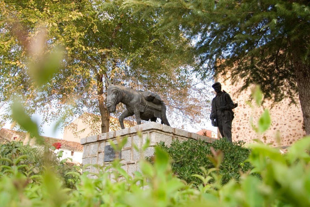
EL ARRIERO
Junto a la iglesia parroquial, obra en bronce realizada por el escultor Ricardo García, de Villanueva de la Serena, inaugurado en 1989. Consiste en un grupo compuesto por un asno y el popular “tierrablanquero”, o vendedor de tierrablanca o cal para enjalbegar las paredes, extraída de las minas de “Juanbueno”, ataviado con la típica chambra o blusón y llevando la romana al hombro.
EL PILAR
Antiguamente destinado a abrevadero, según el modelo tradicional, se conserva en la Plaza de España, restaurado y convertido en fuente.
EL EMIGRANTE
Se encuentra a la salida del pueblo, en Avda. de la Constitución, obra en bronce del escultor zarceño Javier Guerrero González-Piñero. Escultura de un emigrante de pie, con la vista vuelta hacia su pueblo y la maleta al lado.
EL BORRIQUERO
Pozo-abrevadero, con sus correspondientes pilones situado en el camino de Mérida. Es uno de los pozos más valorados, tanto por el agua, como por el servicio que antiguamente ofrecía a los vecinos. Alrededor del mismo, se encontraba una de las distintas eras del municipio. Tiene pilones a ambos lados. Está situado en el camino de Mérida. Hoy en día, es el lugar donde se celebra la subasta de la feria del ganado, a finales de abril o principios de mayo.
GASTRONOMIA
Son platos típicos de la localidad el ajo colorao y ajo blanco, las sopas de tomate, las tradicionales migas extremeñas, los peces de río asados o fritos, el pollo de corral con arroz o tomate y los huevos sucios.
Una gran variedad de repostería tradicional, destacando los bollos de chicharrones y hornazos, así como sus típicas roscas de hojaldre y pasteles elaborados con las recetas originarias en las pastelerías.
COMER Y BEBER
Mesón los Pajares
Avda. de Extremadura, 16. Tel: 924 366 860
Mesón El Arriero
C/ Dulce Chacón, 4. Tel: 924 367 968
Mesón Casa Lopez
C/ Mérida, s/n. Tel: 924 366 350
Bar Restaurante El Pensaero
Pol. Industrial San Marcos. Tel: 924 367 372
Bar Restaurante Punto y Coma
Pol. Industrial San Marcos. Tel: 658 612 700
Bar Restaurante El Centro
C/ Juan Andrés Valor, 19. Tel: 924 36 68 58
Bar Restaurante El Aderezo
Avda. Juan Carlos I. Tel: 924 71 01
Bar Restaurante La Veredilla
C/ La Veredilla, 8. Tel: 649 619 423
Bar Restaurante la Piscina
C/ Veredilla, 30. Tel: 626 375 470
Café-Bar Saturio
Plaza España. Tel: 924 36 62 26
Café-Bar Olimpo
C/ El Pilar, 6. Tel: 924 36 63 02
Café-Bar Corbacho
Plaza Ayuntamiento, 5. Tel: 924 36 75 52
Café-Bar La Parada
C/ Juan Andrés Valor. Tel: 924 36 69 05
Café-Bar La Peña
Travesía de San Martín, 6. Tel: 625 327 021
Bar Zarza
C/ Avda. Constitución.
Café y Copas Noche Negra Pub
Avda. de Alange, 2. Tel: 620 811 029
Salón de celebraciones y eventos Selene
C/ Coso, 13. Tel: 624 36 60 44
Hotel Rural El Arriero
C/ Dulce Chacón, 4. Tlfno: 924 36 79 68
Casa Rural los Cortinales
Avda. Alange. Tlfno: 605 502 341
Hostal El Aderezo
Avda. Juan Carlos I. Tlfno: 722 368 757
Hostal Pensión Casa López
C/ Mérida, 1. Tlfno: 924 36 63 50 / 645 948
FIESTAS
Feria del Ganado. Feria de Mayo
Finales de Abril y principios de Mayo
Fiesta Nuestra Sra. de las Nieves
5 de Agosto
Feria Nuestra Sra. de las Nieves
Feria de Septiembre
Del 7 al 10 de Septiembre
San Isidro
15 de Mayo
San Martín
11 de Noviembre
Ruta de la Tapa
Segundo fin de semana de marzo
Feria Multisectorial
A primeros del mes de octubre
Vive la Calle
A lo largo de 3 viernes de agosto
TELÉFONOS DE INTERÉS
Ayuntamiento: 924 36 60 01
Centro de Salud: 924 36 72 62
Farmacia: 924 36 63 75 / 924 36 75 87
Policía Local: 608 924 842
Bomberos (Mérida): 924 37 28 61
Guardia Civil (Mérida):924 37 02 00
Autobuses (Mérida): 924 37 14 04
Taxi: 924 36 70 31
Hospital (Mérida): 924 38 10 00
La Zarza is located next to the mountain range Sierra del Calvario and very close to the place where the river Matachel flows into the Guadiana river,quite close to the reservoir of Alange. Only 15 Km far from Mérida, although this distance by road rises up to 26 km. It limits with Villagonzalo in the north, Guareña and Oliva de Mérida in the east, Alange in the south and Mérida or Don Álvaro in the west.
As result of being located at the foot of the mountain, the streets of the village were built on steep slope which separate the town into two main areas: the upper area, where the original inhabitants -called cabileños– settled down, and the lowest and modern area, dwelt by the chumberos.
Likely the name of the village testifies the abundance of bushes of thorny branches and sweet fruits of the family of rosaceae, the brambles (Rubus ulmifolius), located on the banks of rivers and streams near the municipality.
Originally, La Zarza was called Zarza de Alange, due to its condition as a village dependent on this bordering municipality, in whose encomienda it was integrated. Throughout the nineteenth and early twentieth centuries, the name was alternately oscillating between Zarza de Alange and Zarza next to Alange. On 20th March 1991 La Zarza acquires its current name, by a decree published in the Official Gazette of Extremadura, thus culminating the old aspiration of independence from Alange. At present, with 3,568 inhabitants, it is the most important population in the region of Tierra de Mérida – Vegas Bajas.
The town is known in the region as «the town of sweets and fur”.
Nature
On the sunny side of Sierra de las Peñas Blancas, there is a local plot of 140.000m2, known as Sierra Utrera, where we can find a remarkable variety of orchid species, thanks mainly to the conservation of space and the diversity of soils in the area. In fact, at least half of the 45 species recorded in Extremadura, occupy different biotopes in this area: mountain slopes with scrub, meadows with pasture lands, banks of rivers and streams, arable benches, etc..
Serapiza perez-chiscanoi, an endangered species which blooms in spring, is the main reason for the declaration of Sierra de Utrera as Place of Scientific Interest.
GUADIANA RIVER
Only 2 km away from the town, the Guadiana river bathes the lands of La Zarza, housing also numerous fauna and flora, and giving us beautiful places to enjoy nature. It is necessary to emphasize the bridge of iron of the railroad built in 1865.
MATACHEL RIVER
The Matachel River is one of the most important tributaries of the Guadiana and, as it passes through La Zarza, it is home to several mills formerly used for milling.
Remarkable valued fauna such as the jarabugo, a fish endemic to the Guadiana, and mammals such as the meloncillo, the genet and wild cat, as well as storks, herons, birds of prey, otters among others can be found.
PEÑAS BLANCAS ROUTE
Peñas Blancas de La Zarza hiking club has been in charge of the organization of the Ruta de Peñas Blancas for years: a medium difficulty route consisting of 19 km takes us through incredible and unexpected places. The panoramic views offered by the ascent of the Sierra de Peñas Blancas or walking through the valley of the Osa or Los Balancines and Sierra de Juan Bueno are added to a route that discovers a small valley between mountains, unknown and surprising.
The route combines important environmental elements as well as historical, artistic and ethnographic stops. Halfway up the slope we reach La Cueva de la Calderita, perfectly signposted, where we find cave paintings, evidence of the first settlers. When crowning the mountain range, fertile lands full of olive trees and pasture lands at Vega del Guadiana are spotted. The Roman city of Mérida can be seen at the at the background, as well as Alange, the reservoir and its castle. Views continue along the slope of Sierra de Las Molineras to crown the Port of Las Hoyas and going down on the shady side. The organization offers the possibility of making an alternative route without climbing the 15 km mountain range, by the easiest way into the Osa Valley.
CAVE PAINTINGS
Declared Asset of Cultural Interest, Abrigo de La Calderita is located 2 km southwest of La Zarza, at Sierra de Peñas Blancas.
They were discovered by 1920’s thanks to the prospecting work of Henri Breuil and his unconditional assistant Tomás Pareja.
It is a set of the purest schematic style, both for the technique used and for the typologies and themes represented. The coat is on a large quartzite wall of more than ten metres long. Its wide rocky surfaces served as a canvas on which several hundred figures were captured, painted on red and continuous strokes of different thicknesses, combining thick -using fingertips for some figures- and fine -using small brushes or applications of vegetable fiber or animal- for others. Figures of many varied types are combined and associated.
The paintings are classified into 5 groups: masculine and feminine branch-shaped figures (upright axis crossed by horizontal lines, simulating trunk and extremities) and others of triangular shaped type (with two or three inverse and superimposed triangles). Among the zoomorphic figures distributed on the panels, different examples of quadrupeds of the pectiniformes type (a horizontal line and several vertical ones, similar to a comb). Ideomorphs are represented by tectiformes (reticulated forms associated with maps, constructions or traps), soliforms (sun), dots and fingering.
JUAN BUENO MINES
Throughout the twentieth century and early twenty-first, the mine of ‘Juan Bueno’ was firstly handicraft tapped and later on, it was operated under mining extraction grant, reflected in the mine sites of ‘La Zarceña’ and ‘San Rafael’.
They are open-pit mines located 1.5 km from the town, at a place known as Juan Bueno, where a cord for cattle separates the end of Sierra del Calvario from the beginning of Sierra de los Barreros. The starting point is the ruined building of an old clay mine located almost in the same place. From a topographical point of view, the mine passes through the paths from La Zarza to Guareña and Oliva de Mérida. It is located on the watershed of the Calera stream, a tributary of the Matachel river.The kaolin or tierrablanca was laboriously and painfully handicraft extracted by the barreros and sold by the tierrablanqueros helped by their donkeys through the villages of the region. The product is typically used to whitewash the houses walls.
MILLS
La Zarza held six flour mills: two by the Guadiana and the rest were located by the Matachel river.
The Rabia mill is the best preserved of those located on the banks of the river Matachel.
It was endowed with five pairs of millstones, four of which remain in their original place and others were reused as part of the pavement. It is made of plastered masonry combined with bricks in the arches. The roof is gabled with barrel vaults inside, made of brick and also plastered. The length of the nave makes of it the largest mill in the surrounding area and for this reason it was necessary to build transverse arches for the reinforcement of the barrel vault, also made of bricks.
There is a small room equipped with a chimney just above the third pair of molars.
THE JARRO
It was luckily found by some peasants on the outskirts of La Zarza.
It is a piriform bronze 30 centimeters high and 12 cm wide-container, of almost a kilo and a half of weight and around one litre-volume.
Morphologically the deer head-shaped embouchure stands out. The central part of the body is decorated with large bead moulding, two palmettes on the handle almost missing.
The jug of La Zarza dates from the 7th century B.C. -from the time of the Tartessos. It is kept in the archaeological museum of Badajoz.
SAN MARTIN DE TOUS CHURCH
Declared an Asset of Cultural Interest, it is located in the upper side of the village. In the 16th century-building, different stages can be seen, thus observing some formal differences between the chancel, which is a bit older, and the nave. The two façades were posterior built, probably from the 17th century. An element of singular interest is the credence or niche similar to others found in the region of Merida.
It is distributed through a single large nave, with large head, in three sections, in addition to the atrium entrance.
The exterior shows rigid box structure.
The head of great proportions was planned in two areas: the presbytery and the main chapel, both covered by a star-shaped vault on corbels and the head of a polygonal apse with a similar roof. A small sacristy and two small chapels join the main body forming the Latin cross structure.
On the left panel of the main chapel, there is a niche-sagrary, framed by a representation of a façade of notable interest, executed in stone, being a work of Renaissance style, whose filigree is similar to the Parish Church of Candelaria de Fuente del Maestre. Formally, it is a carpanel arch span on a wide band decorated with grottoes, a shield in the keystone and small medallions in the spandrels, flanked by fine columns.
NUESTRA SEÑORA DE LAS NIEVES HERMITAGE
Dating from early 18th century, it is located in the lower part of the town. It is named after the patron saint of the village although it was formerly dedicated to the holy martyrs San Fabián and Sebastián.
The hermitage is a notable proportions construction, with a Latin cross plan and a nave divided into 4 sections and transept covered with dome – the sacristy and the shrine of the Virgin are at the back, also covered with dome- resulting in a structure of double octagonal dome from outside.
Among its most outstanding elements are the dressing room, the main altarpiece and the Carro de la Virgen (Chariot of the Virgin).
In the dressing room there are paintings that cover the dome, its pendentives and the walls, which was restored at the end of the 20th century, with scenes of the birth of Jesus, flight into Egypt, Epiphany and others. In the pendentives, King David and other Biblical characters can be seen. In the dome between rococo style frames there are 8 strong women from the Bible (Jael, Abigail, Esther, María, Judit, Sara, Deborah and Ruth). In the dome of the transept, tempera paintings cover it with scenes of the Coronation of the Virgin emblazoned with angels. In the pendentives we can see canvases with different scenes from the history of the Virgen de las Nieves.
The atrium of the hermitage was the meeting place for all young people from the 1940s to the 1960s.
THE ARRIERO
Next to the parish church, bronze work made by the sculptor Ricardo García, from Villanueva de la Serena, was inaugurated in 1989. It consists of a group of sculptures made up of a donkey and the popular tierrablanquero dressed with the typical chambra or blouse and carrying the scales on his shoulder.
THE BASIN
Formerly used as watering place, according to the traditional model, it is preserved at Plaza de España, after restoration and reconvertion into a fountain.
THE EMIGRANT
It is located at the exit of the village, in Avda. de la Constitución, a bronze work by the Zarceño sculptor Javier Guerrero González-Piñero. The sculpture shows an emigrant standing, with the view back to his village and the suitcase next to it.
THE BORRIQUERO
Watering place with its corresponding pylons on both sides located on the road to Merida. It is one of the most highly valued wells, both for the water and the service offered to its neighbours. Nowadays, it is the place where the auction of the livestock fair is held, at the end of April or beginning of May.
GASTRONOMY
Coloured garlic and white garlic, tomato soups, the traditional migas extremeñas, river fish roasted or fried, poultry with rice or tomato and dirty eggs are typical dishes of the town.
There is a great variety of traditional pastries, such as crackling and hornazos buns, as well as the typical puff pastry rolls and cakes made with their original recipes in the bakeries.
WHERE TO EAT AND SLEEP
Mesón los Pajares
Avda. de Extremadura, 16. Tel: 924 366 860
Mesón El Arriero
C/ Dulce Chacón, 4. Tel: 924 367 968
Mesón Casa Lopez
C/ Mérida, s/n. Tel: 924 366 350
Bar Restaurante El Pensaero
Pol. Industrial San Marcos. Tel: 924 367 372
Bar Restaurante Punto y Coma
Pol. Industrial San Marcos. Tel: 658 612 700
Bar Restaurante El Centro
C/ Juan Andrés Valor, 19. Tel: 924 36 68 58
Bar Restaurante El Aderezo
Avda. Juan Carlos I. Tel: 924 71 01
Bar Restaurante La Veredilla
C/ La Veredilla, 8. Tel: 649 619 423
Bar Restaurante la Piscina
C/ Veredilla, 30. Tel: 626 375 470
Café-Bar Saturio
Plaza España. Tel: 924 36 62 26
Café-Bar Olimpo
C/ El Pilar, 6. Tel: 924 36 63 02
Café-Bar Corbacho
Plaza Ayuntamiento, 5. Tel: 924 36 75 52
Café-Bar La Parada
C/ Juan Andrés Valor. Tel: 924 36 69 05
Café-Bar La Peña
Travesía de San Martín, 6. Tel: 625 327 021
Bar Zarza
C/ Avda. Constitución.
Café y Copas Noche Negra Pub
Avda. de Alange, 2. Tel: 620 811 029
Salón de celebraciones y eventos Selene
C/ Coso, 13. Tel: 624 36 60 44
Hotel Rural El Arriero
C/ Dulce Chacón, 4. Tlfno: 924 36 79 68
Casa Rural los Cortinales
Avda. Alange. Tlfno: 605 502 341
Hostal El Aderezo
Avda. Juan Carlos I. Tlfno: 722 368 757
Hostal Pensión Casa López
C/ Mérida, 1. Tlfno: 924 36 63 50 / 645 948
PARTIES CORREGIDA
Cattle Fair. May Fair
End of April and beginning of May
Festivity of Our Lady of the Snows
August 5th
Our Lady of the Snows Fair
September
From 7th to 10th September
San Isidro
May 15th
St. Martín
November 11th
Route of the Tapa
Second weekend of March
Multisectorial Fair
At the beginning of October
Live the Street
Throughout 3 Friday in August
CONTACT TELEPHONES
Town Hall: 924 36 60 01
Health Centre: 924 36 72 62
Chemistry: 924 36 63 75 / 924 36 75 87
Local Police: 608 924 842
Firefighters Station (Mérida): 924 37 28 61
Guardia Civil (Mérida):924 37 02 00
Bus Station (Mérida): 924 37 14 04
Taxi: 924 36 70 31
Hospital (Mérida): 924 38 10 00
